Breathtaking views of the Rhône River
DIDIER HEUMANN, ANDREAS PAPASAVVAS
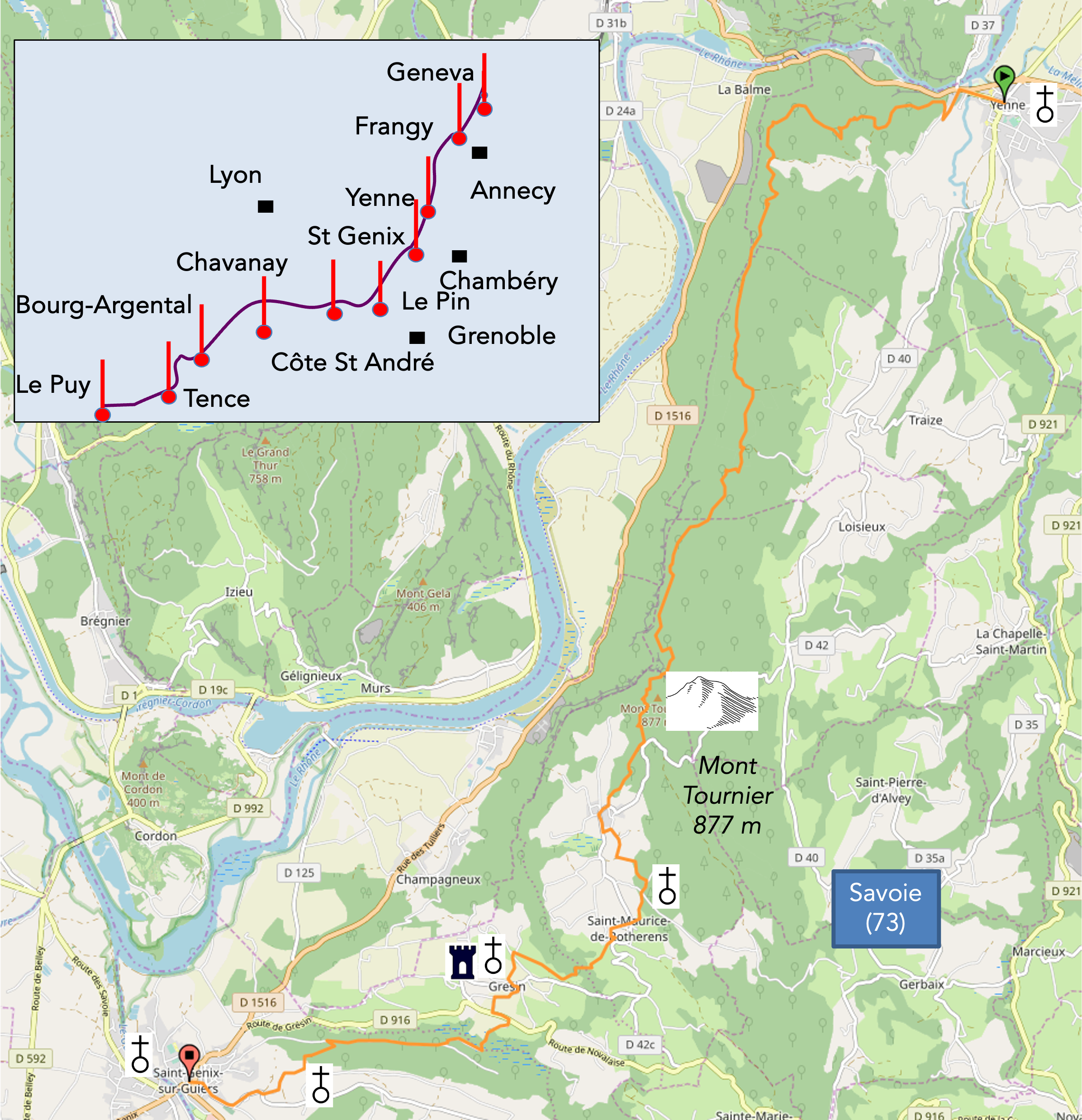
We divided the course into several sections to make it easier to see. For each section, the maps show the course, the slopes found on the course, and the state of the route (paved or dirt roads). The courses were drawn on the « Wikilocs » platform. Today, it is no longer necessary to walk around with detailed maps in your pocket or bag. If you have a mobile phone or tablet, you can easily follow routes live.
For this stage, here is the link:
https://fr.wikiloc.com/itineraires-randonnee/de-yenne-a-st-Rotherens-sur-guiers-par-la-via-gebennensis-34098402
| Not every pilgrim feels comfortable using GPS devices or navigating on a phone, especially since many sections still lack reliable internet. To make your journey easier, a book dedicated to the Via Gebennensis through Haute-Loire is available on Amazon. More than just a practical guide, it leads you step by step, kilometre after kilometre, giving you everything you need for smooth planning with no unpleasant surprises. Beyond its useful tips, it also conveys the route’s enchanting atmosphere, capturing the landscape’s beauty, the majesty of the trees and the spiritual essence of the trek. Only the pictures are missing; everything else is there to transport you.
We’ve also published a second book that, with slightly fewer details but all the essential information, outlines two possible routes from Geneva to Le Puy-en-Velay. You can choose either the Via Gebennensis, which crosses Haute-Loire, or the Gillonnay variant (Via Adresca), which branches off at La Côte-Saint-André to follow a route through Ardèche. The choice of the route is yours. |
 |
 |
If you only want to consult lodging of the stage, go directly to the bottom of the page.
In this late autumn, a veil of fog envelops the Rhône Valley, lending the atmosphere an air of mystery. Today’s hike is one of the most majestic on the Camino de Santiago, offering breathtaking panoramic views of the Rhône River. This stage, considered the jewel of the Via Gebennensis on a clear day, traverses the vast Recoba Forest and extends over a small mountain that separates the Yenne enclave from the expansive Rhône plain. At the summit of this mountain stands the modest Mont Tournier Pass, a winding and lightly trafficked road. The first part of the stage takes place mainly within the depths of the forest, punctuated by enchanting viewpoints that offer stunning views of the Rhône’s meanders below. These panoramas are best enjoyed on a sunny day to fully appreciate the magic of this stage. Unfortunately, pilgrims do not always enjoy this privilege and may have to contend with the whims of the weather. The variety of landscapes, the richness of the flora, and the tranquility of the forest make this hike a unique and memorable experience. Here, nature reveals its full splendor and serenity, inviting walkers to deep introspection and communion with the surrounding world. This challenging but rewarding trek leaves a sense of accomplishment, a tangible testament to the intimate connection between humanity and nature. Traverse the enchanting forests, gaze upon the rolling landscapes, and immerse yourself in the magic of this timeless journey.
However, be cautious at the start from Yenne, as there are two paths leading to Mont Tournier. Avoid the variant that begins in the heart of the village and opt for the GR65, which starts at the edge of Yenne, near the cemetery.

Difficulty level: Crossing a pass means unavoidable elevation changes. This stage is undeniably demanding. The altitude variations (+992 meters/-987 meters) reflect the balance between ascents and descents. Starting from the Rhône’s banks, the trail climbs to 850 meters before descending almost back to the starting level. Despite its imposing appearance, Mont Tournier is not a true mountain. You might feel the climbs less due to intermediate flat and downhill sections. The journey begins at 230 meters in altitude and gradually ascends over more than 12 kilometers, making the climb less steep. The descent, though occasionally taxing on the joints, remains manageable, with some flat stretches for recovery. At the end of the stage, a final challenge awaits with a steep climb up a hill before completing the route.
State of the GR65: This stage primarily traverses forest paths, offering a rare respite from the asphalt of the Camino de Santiago, where nature takes precedence:
- Paved roads: 6.9 km
- Dirt roads : 17.5 km
Sometimes, for reasons of logistics or housing possibilities, these stages mix routes operated on different days, having passed several times on these routes. From then on, the skies, the rain, or the seasons can vary. But, generally this is not the case, and in fact this does not change the description of the course.
It is very difficult to specify with certainty the incline of the slopes, whatever the system you use.
For those seeking « true elevations » and enthusiasts of genuine altimetric challenges, carefully review the information on mileage at the beginning of the guide.

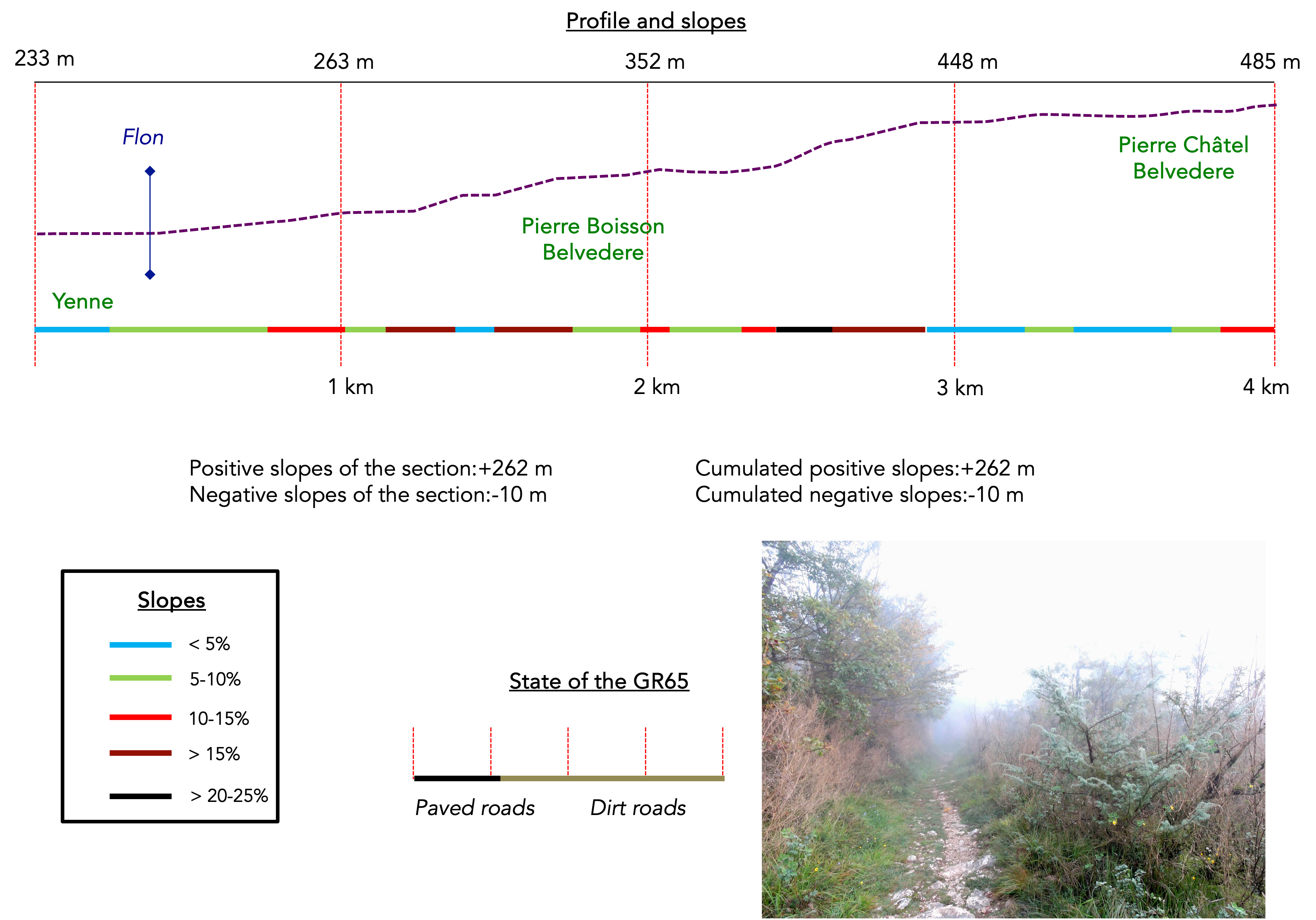
Section 1: On the initial switchbacks leading to Belvedere Pierre Châtel
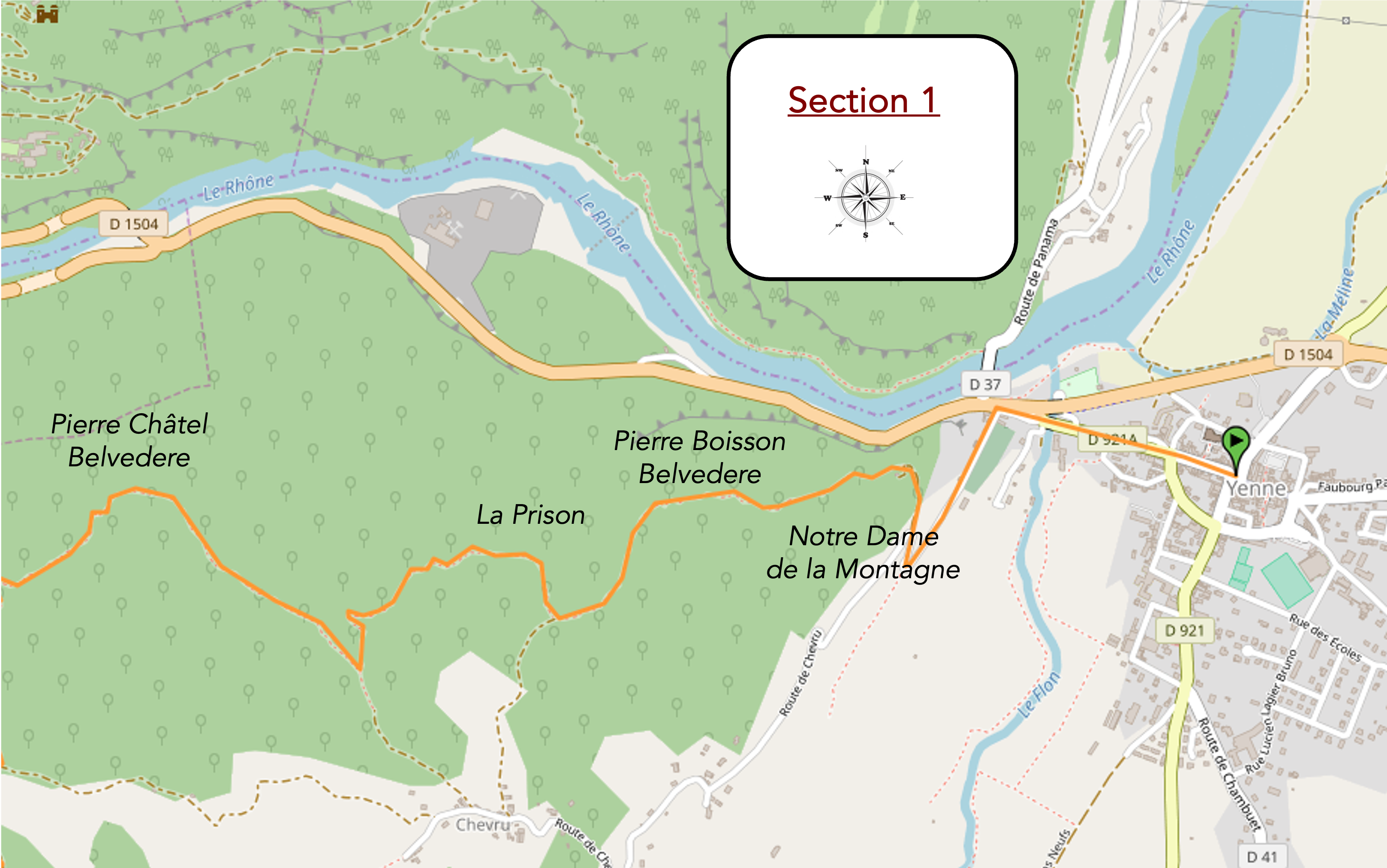
Overview of the route’s challenges: Paradoxically, despite the long ascent to the pass, you won’t always perceive a steep gradient. However, certain sections exceed 15% incline significantly. Reviewing the profile of this segment will give you a sense of the difficulty involved.
|
Today, there is thick fog, but the weather forecast looks accurate. From the center of Yenne, you must cross the small town in its entirety towards the Rhône, reaching the roundabout where the Flon stream flows. This modest but lively little river adds a touch of freshness to this picturesque corner.
|
 |
 |
|
There, a bridge spans the Rhône, and nearby is the cemetery, shrouded in a mysterious aura due to the persistent fog. The road seems to dissolve into this thick mist, barely revealing its winding path.
|
 |
 |
|
The road runs alongside the cemetery, gently sloping up before turning into a rocky path after a bend. A wild and untamed path stretches for more than 10 kilometers, promising a walk that is both rough and exhilarating. It is more often a relatively narrow trail than a wide path.
|
 |
 |
|
Soon, the GR65 reaches the Chapel of Notre-Dame de la Montagne, nestled under the pines and enveloped in a ghostly fog. The statue of the Virgin, erected in 1860, stands proudly, embedded in a mound of large stones, with its open gate inviting contemplation. This chapel, with its palpable serenity, stands as a protective sentinel over Yenne and the Rhône.
|
 |
 |
From this point onward, and for much of the ascent, limestone frequently emerges, sculpting the trail with its rugged features. The narrow and capricious trail challenges hikers with its short but steep slopes, flat sections, and occasional descents, creating a varied walking rhythm.

The first viewpoint quickly appears: the tomb of Pierre Boisson. Born in 1819, this local figure—wealthy dentist and Freemason—wished to be buried in Yenne’s cemetery near the Madonna of the Mountain. When this was refused, he had his own tomb erected across the valley. Today, the fog obscures the view, hiding the tomb on the opposite bank of the river and barely revealing the contours of a rugged landscape, populated by bare trees.

| The fog is persistent today, but the weather forecast does not predict rain, and it should eventually clear, revealing a ground covered with fallen leaves, polished limestone slabs, and sometimes reddish dust. The shrubs, lacking sunlight but not moisture, are often covered with creeping lichens resembling the hair of gorgons, giving the landscape a wild and disheveled appearance. |
 |
 |
A bit further up, on the broad stones between heathland and forest, the trail runs by a place called La Prison. But today, the only prison is this dense and all-encompassing fog. In just half an hour of walking, you’ve already gained over 100 meters of altitude from Yenne. The Pierre Châtel viewpoint is announced as being 40 minutes away, with St Maurice-de-Rotherens further along at 4 hours and 45 minutes of walking.

| The trail continues to climb, but with a gentler gradient. In this cotton-like fog, the GR65’s shell often remains the only reliable guide to avoid false trails scattered across the mountain. For now, the landscape remains unchanged: sparse bushes, slender shrubs, and scattered stones adorn this trail that traverses a magical, mysterious, and almost eerie steppe. |
 |
 |
| Higher up, the incline becomes steeper over a short stretch, where stones are abundant. Moraines deposited these materials during the Quaternary glaciations, but the small chestnut trees have also shed their leaves during the previous winter. |
 |
 |
| You are walking through a landscape that fluctuates between heathland and scrub rather than a true forest. You are very close to the cliff, but it remains hidden by the fog. Fortunately, the thick mist seems to be lifting, at least partially. This anticipation brings a smile despite the steep incline. |
 |
 |
| We then experience one of those fleeting, psychedelic moments when the sun begins to play with the fog. The trees become clearer: the gnarled oaks and bare chestnut trees. |
 |
 |
The sun peeks out timidly as we reach the Pierre Châtel viewpoint. From La Prison, you have climbed from 345 meters to 480 meters in altitude.

| The Pierre Châtel fortress, across the Rhône, was the favored secondary residence of the Counts of Savoy. Originally built as a convent at the end of the 14th century, it was long guarded by Carthusians. The fortress was besieged by the Austrians in 1814 during Napoleon’s era and lost its strategic role when Savoy was annexed by France in 1860. |
 |
 |
With the fog, the place takes on an even more fantastical appearance, allowing the imagination to picture enemies scaling the walls.

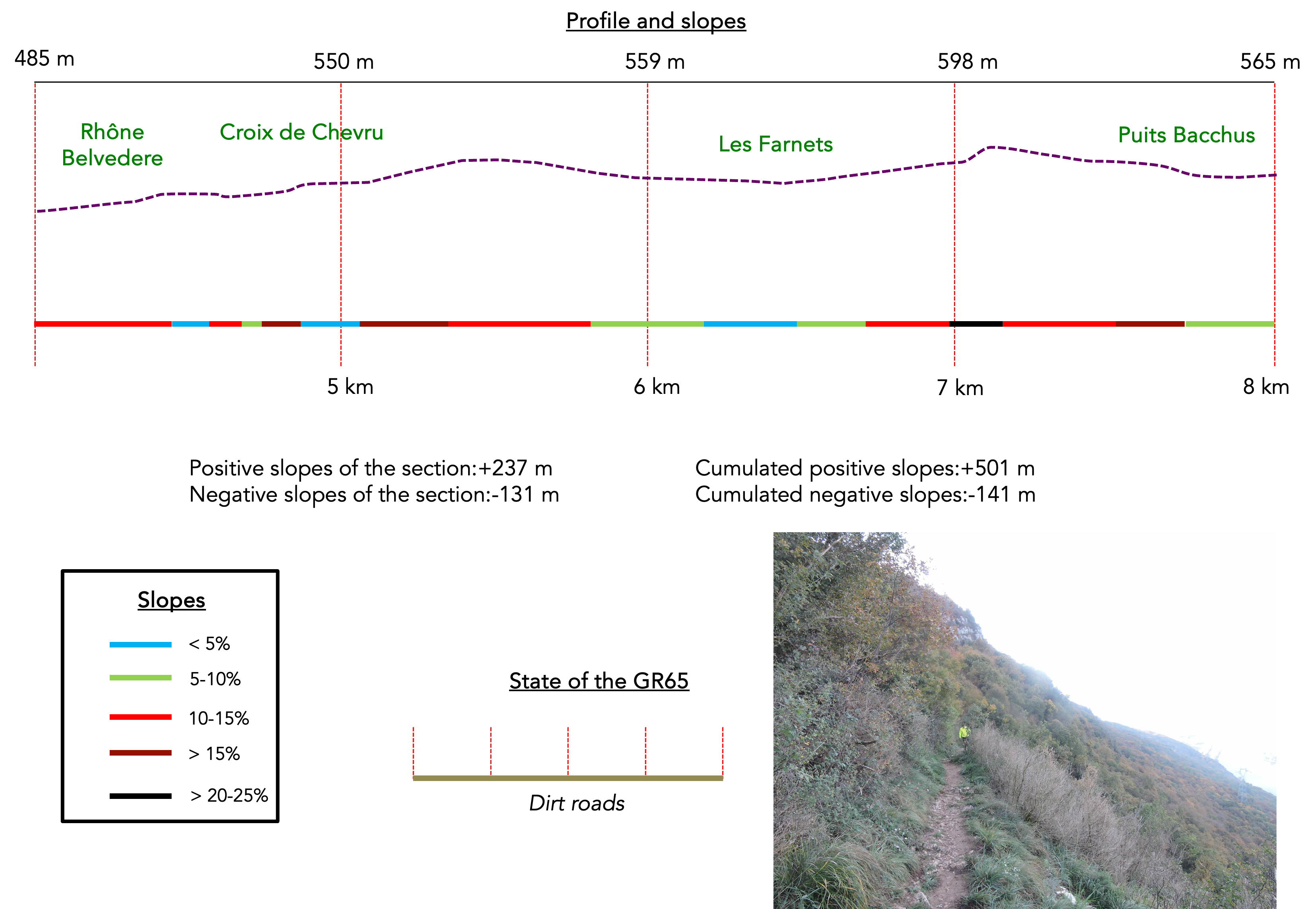
Section 2: Breathtaking views of the Rhône River

Overview of the route’s challenges: Paradoxically, during this long ascent to the pass, you won’t always feel the steep gradient. The trail continuously undulates, with sections climbing and descending, and some segments exceeding 15% incline. Reviewing the profile of this segment will provide a sense of the challenge it presents.
| On this side of the mountain, the fog seems reluctant to yield to brighter light. |
 |
 |
Fortunately, just above, the Rhône Belvedere already reveals itself under the sun’s rays.

| This offers a tantalizing preview of what lies ahead, where the beauty of the Rhône Valley panorama captivates the senses. Through the bushes, the view expands into a valley of breathtaking splendor. The proximity of the cliff is palpable, though not immediately threatening. Here, however, the river remains hidden, like a secret kept by nature. The cliff’s closeness is hinted at by the mist clinging to the steep slopes, giving the scene a simultaneously mysterious and grandiose aura. |
 |
 |
| The trail continues its gentle ascent, moving slightly away from the cliff among large limestone blocks scattered in a heath where skeletal shrubs, draped in lichens and thick mosses, resemble the hair of ancient fairies asleep for centuries. |
 |
 |
| After a small clearing, it plunges again among deciduous trees, climbing onto a small plateau. Here, the slender, leafless chestnut trees have definitively taken over from the few remaining deciduous trees. Ivy, lichen, and moss infiltrate everywhere within this rustic thicket, which seems frozen in time. |
 |
 |
| Soon, the trail approaches the Chevru Cross, perched at 545 meters altitude. This imposing 700 kg cross, dating from 1630, evokes a timeless divinity. It was part of a set of three crosses that once served as centers of devotion and pilgrimage. At the beginning of the 20th century, this place was animated by a pasture, but today the forest and vegetation have reclaimed it, while devotion has waned. |
 |
 |
| From the Croix de Chevru, the trail meanders incessantly, sometimes descending, through skeletal deciduous trees. The thinness of these trees seems inexplicable in this environment. At the end of autumn, the deciduous trees have shed their foliage, leaving bare trunks and carpets of dead leaves. While the lower forest is often dominated by underbrush and shrubs, higher up, modest beech and maple trees, as well as pubescent oaks, appear in search of light. |
 |
 |
In this vast forest dominated by deciduous trees, the scattered fragile chestnut trees seem to form a disciplined formation. Conifers are scarce. One cannot predict what the scenery would look like in another season. In this autumnal moment, everything is wild, almost apocalyptic, evoking a landscape of divine grandeur. The trail soon passes by Les Farnets, 3 hours and 15 minutes from St Maurice-de-Rotherens. Places with possible trail intersections are often named here.

| After crossing Les Farnets, an enigmatic name where trails intersect like intertwined destinies, the path unfolds in gentle undulations under the cover of chestnut trees. Dead leaves mixed with limestone stones greet each step with a soothing murmur, as if the forest itself is whispering secrets. |
 |
 |
| Then, like a marvel, the Rhône suddenly appears below, a winding azure river, like an anaconda from the depths of the Amazon, contrasting magnificently with the shades of green and brown dominating the autumnal landscape. From this point, the path transforms into a fairy-tale trail along the Recorba cliffs. Up here, suspended between sky and water, each step reveals an enchanting and vertiginous view that envelops the soul like a caress from the wind. The steep Recorba cliffs stand as ancient guardians, gazing over the river for centuries. The emotion is palpable, almost tangible, as if every breath of wind whispers an ancient story and every ray of sunlight paints a fleeting yet eternal tableau. |
 |
 |
| The jogger who frequents this path twice a week cannot do without this spectacle. Hypnotized, he says. |
 |
 |
| At times, the trail loses sight of the Rhône bank only to find it again a little further on, meandering delightfully through the steppe above the cliffs. The atmosphere here is indescribably magical, where each undulation of the path seems to tell a new story. The view is grandiose, with the Rhône appearing and disappearing according to the meanders of the trail, like a silver ribbon gracefully flowing through the landscape. |
 |
 |
| The spectacle momentarily pauses when the trail turns behind the cliff and plunges back into the dense forest. This return to the sylvan shadows is merely a pause in the enchantment, an invitation to patience before rediscovering the majesty of the open panoramas. |
 |
 |
| IHere, a few pines have taken root, and even without paying much attention, you will notice that the trees have grown taller, likely due to a renewed influx of light piercing through the canopy. |
 |
 |
The trail then begins a slight descent into the heart of the forest, reaching the place called Puits Bacchus at 550 meters altitude. This is another fork in your route, a stop where the trail continuously undulates, without significantly gaining altitude since the Chevru Cross. Yet, time seems to stand still, as the scenery is so enchanting and magnificent, like a living painting unfolding with each step.

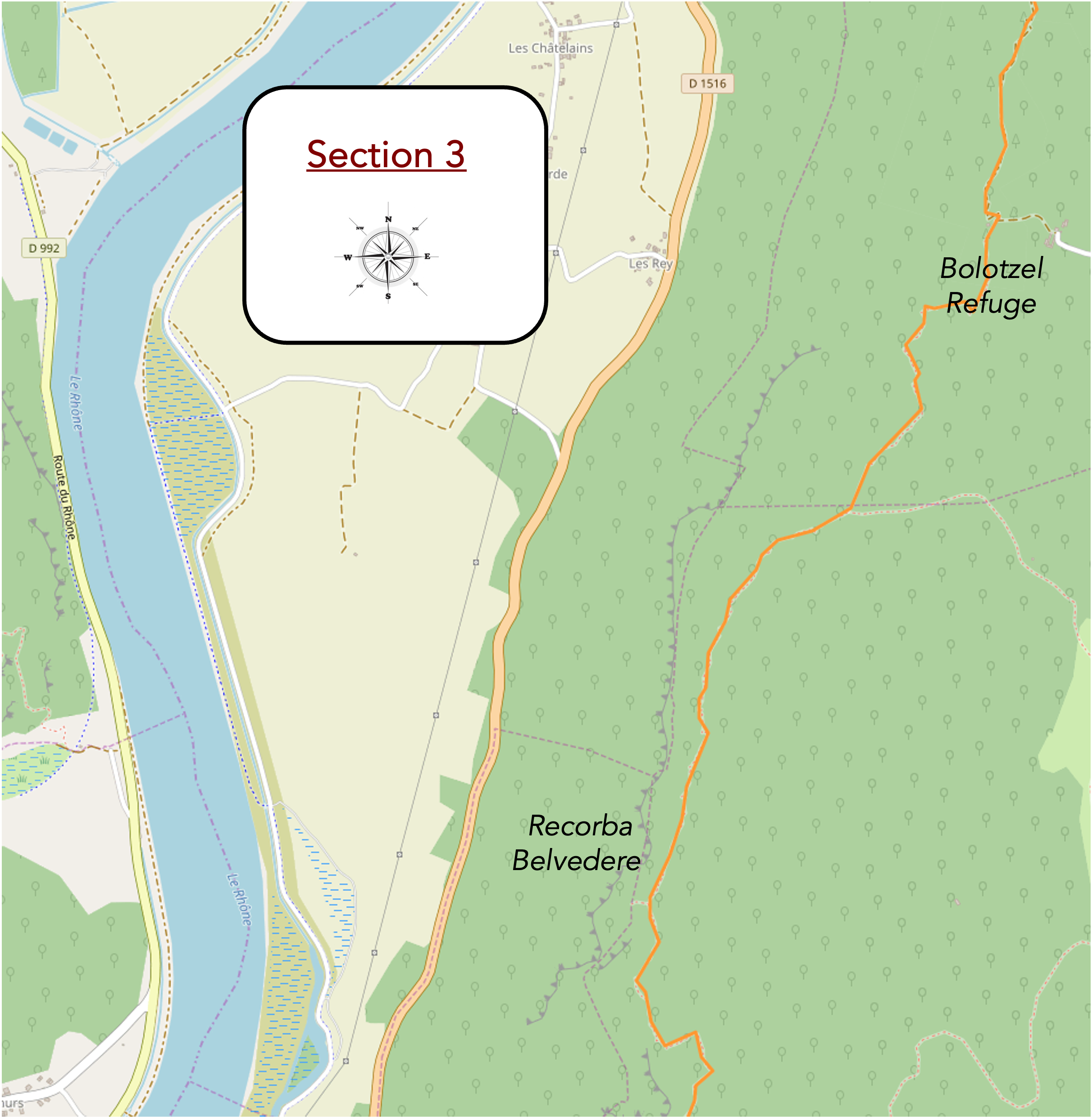
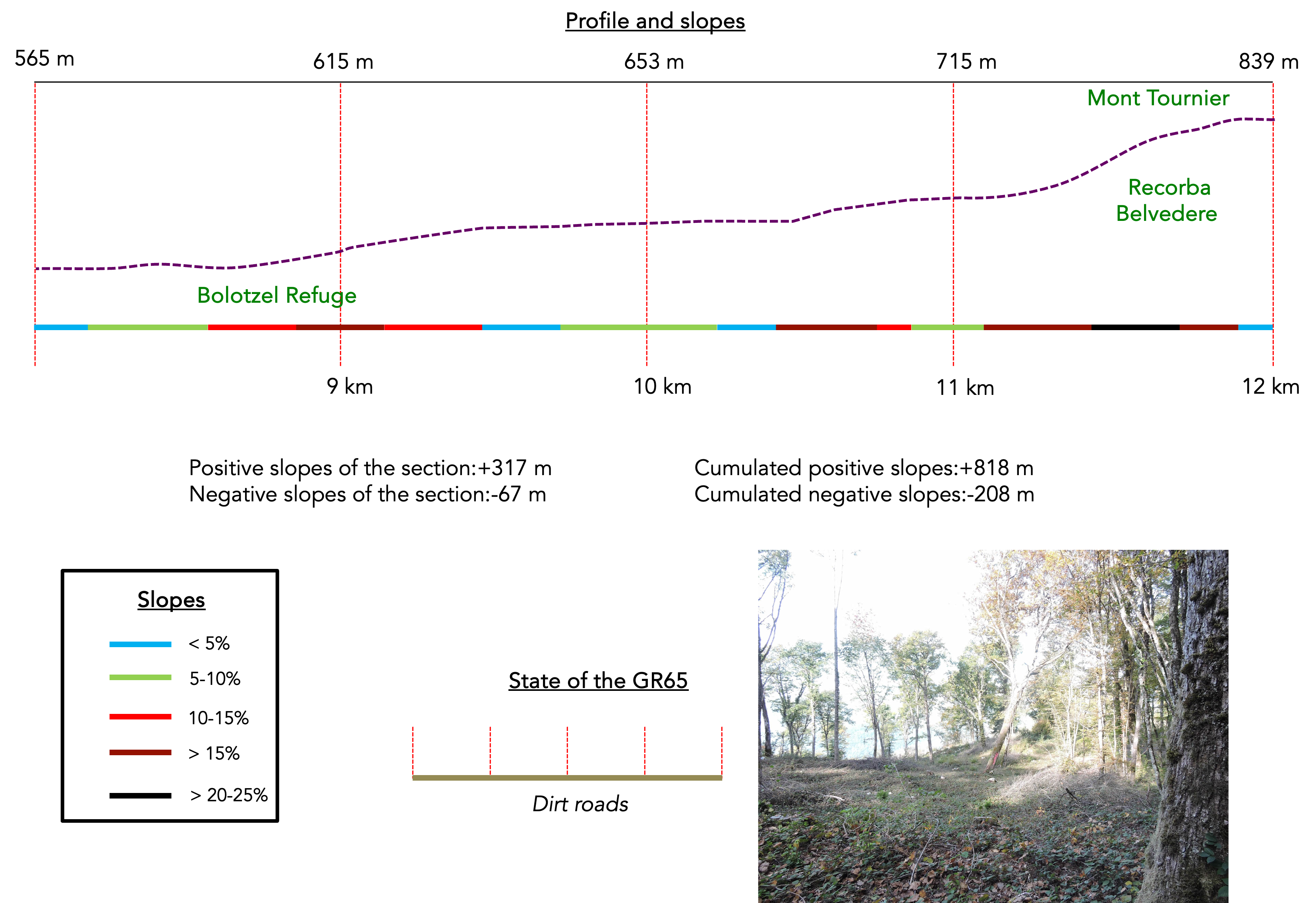
Section 3: It’s even more beautiful at the Recorba Belvedere
Overview of the route’s challenges: Only the final slopes leading to the pass are truly very steep, sometimes approaching a 25% incline. Reviewing the profile of this segment will give you an idea of the difficulty involved.
| From Puits Bacchus, it’s as if you enter a new forest. The scraggly shrubs and underbrush have given way to a much more organized vegetation. a path, now wider and less rocky, meanders gently over a carpet of fallen leaves. |
 |
 |
The path then crosses the place called Les Saradins. These signposts are essential in this forest, where many other trails intersect and wind through the mountain. Your direction remains towards St Maurice-de-Rotherens, on the Camino de Santiago.

| Higher up, the path meanders among majestic beeches, imposing oaks, and various conifers, including pines and spruces. The chestnut trees, now more robust and commanding, will accompany you faithfully for several days. |
 |
 |
| Ahead, a vast clearing unfolds, the first open space since your departure, offering a breath of fresh air and light in this forest immersion. |
 |
 |
| In the now denser forest, the GR65 reaches the Botozel refuge, a peaceful haven for the hunters of Loisieux, a small village nestled below the forest. |
 |
 |
This secluded refuge provides a refreshing water source and, during hunting season, you might have the privilege of entering. The hunters, masters of this woodland domain, seem to view the forest as their realm but do not hesitate to share this generous nature with adventurous hikers. In the past, this area served as a refuge for people resisting Nazi oppression, adding a historical depth to this place of peace and memory.

| From here, the path takes on more of the appearance of a trail. It then plunges into the Loisieux hunting grounds, crossing the Glaize woods where deciduous trees and conifers coexist harmoniously. |
 |
 |
| This forest, a mosaic of greens and browns, is a hunting ground where deer, wild boars, and even chamois share their space with humans. In autumn, hunting is not allowed every day, enabling mushroom pickers and hikers to enjoy this place safely. The local hunters, attentive and respectful, ensure that their activities do not disturb walkers, maintaining a peaceful coexistence in this natural sanctuary. Fortunately, because no blank shots here! |
 |
 |
| The trail then gains a bit more altitude, climbing over 100 meters to reach the Recorba Belvedere. The sustained but steady slope stretches beneath the bare autumn trees. Occasionally, you might watch for a wild boar to dart away, but today, the forest seems strangely silent, as if holding its breath. Not even a bird disrupts the tranquility of this place, reinforcing the impression of being in a sanctuary outside of time. |
 |
 |
| Higher up, the trail offers a welcome pause on a flat area where chestnut trees intertwine, their gnarled trunks forming a natural arch above the path. The air here is fresh and invigorating, providing a moment of respite before continuing the climb. |
 |
 |
| The trail then leads to the Recorba Belvedere, standing at 690 meters altitude. You are reminded that you are in a private forest, carefully maintained by the hunters of Loisieux. Fifty meters from the trail, the belvedere reveals itself, promising breathtaking views. |
 |
 |
And what a spectacle! To say it is beautiful would be an understatement. Here, above the vertical cliff, the view is simply exceptional. The panorama stretches beyond imagination, offering a spectacular glimpse of the valley belows.

| From the belvedere, your gaze plunges into the depths of the valley, encompassing an expanse so vast that you might almost believe you can see Lyon on the distant horizon. The Rhône, appearing as a mere 300-meter-wide blue stream, winds through the land like a giant worm. It is a sight both majestic and soothing, reminiscent of viewing a great river like the Mississippi or the Amazon from an airplane window. Nature, in all its splendor and generosity, presents itself here without reservation. |
 |
 |
| IHere, the most daring slopes of this ascent become apparent, sometimes challenging climbers with inclines nearing 25%. This trail climbs from 690 meters altitude to approach 850 meters, almost reaching the venerable summit of Mont Tournier. However, this climb, though vertiginous, is not interminable. |
 |
 |
| In this exalted landscape, the stones, relentless underfoot, testify to the roughness of the trail. At times, the carpet of leaves scattered by the season softens the harshness of the route, providing ephemeral softness beneath your soles. |
 |
 |
Section 4: Descending from Mount Tournier

Overview of the route’s challenges: It’s mostly downhill, with occasional flat sections or even uphill stretches. However, it’s not an easy descent, with sometimes steep slopes.
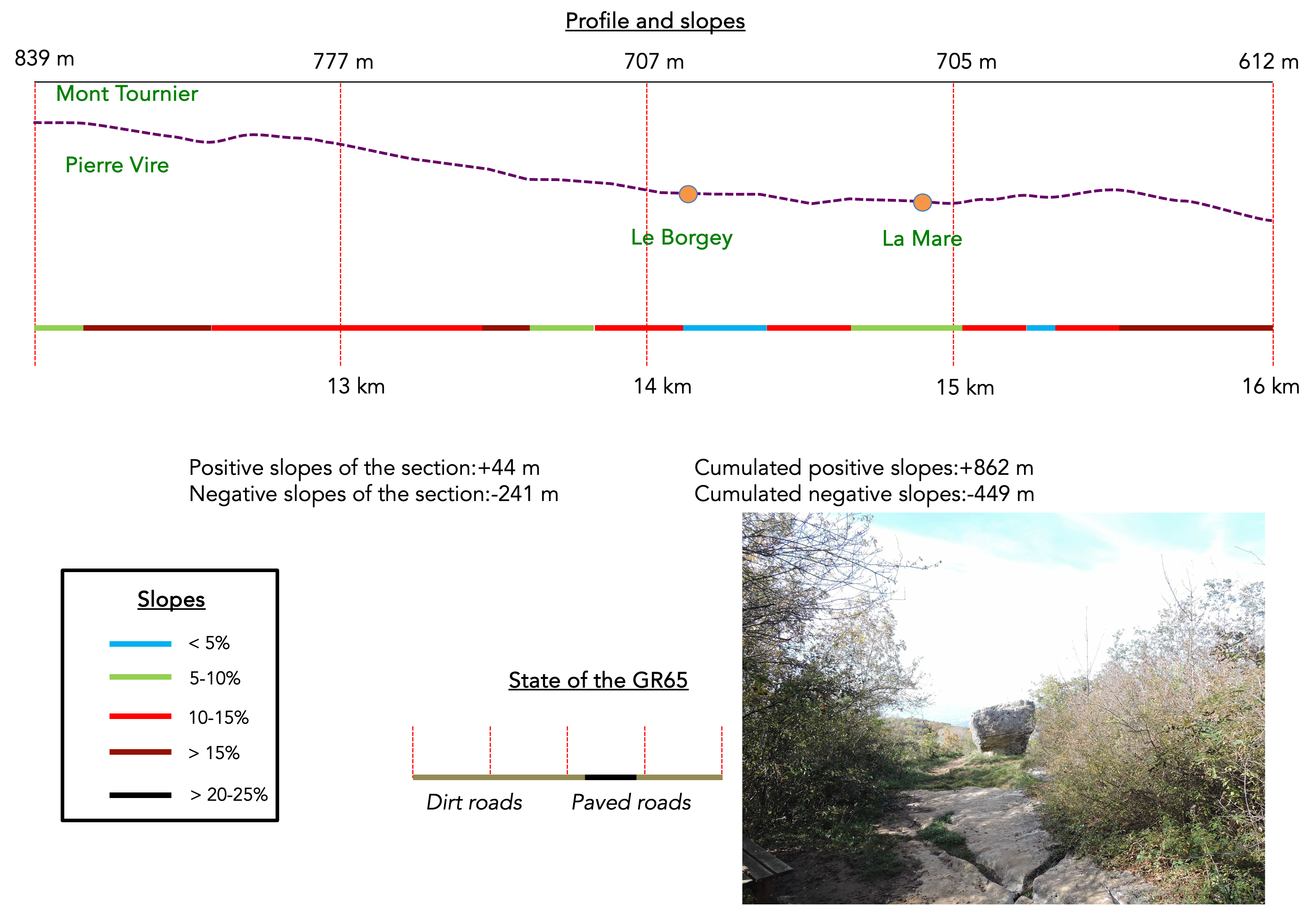
| The trail winds almost to the summit of Mont Tournier, which is more of a large rounded hill rather than a true mountain. You may feel like you never faced a strenuous climb due to the flats and gentle descents. Nevertheless, you start at 230 meters in altitude to reach 850 meters, but over a distance of more than 12 kilometers, the effort spreads out, almost imperceptible.
Soon, the trail begins to undulate on a gentle slope in a forest that becomes increasingly dense. The walk is soft and pleasant, with trees forming a guard of honor to salute your perseverance. The surrounding nature, with its shades of green and woody scents, creates a serene and enchanting atmosphere. |
 |
 |
| Then, the trail descends slightly again, still through the forest. It seems to want you to enjoy every feature of the terrain and unexplored viewpoints. |
 |
 |
| It descends until it reaches two places, first Sérus and then, a few steps away, Pierre Vire, located at 820 meters altitude. Here, the return to civilization is announced to be less than an hour away. It must be said, you won’t encounter many people on this route, and that’s just as well! Especially since it’s impossible to get lost, as the path is perfectly marked. The solitude of the walk allows you to fully immerse yourself in the beauty and tranquility of the surroundings. |
 |
 |
| A « pierre qui vire » is simply another name for a rocking stone. At the Pierre Vire site, the view extends over the gentle hills overlooking St Genix-sur-Guiers. The Rhône winds towards other horizons, and you will encounter it again in a few days, near Vienne, after it detours through the city of Lyon. |
 |
 |
| The trail then meanders through the lush vegetation at the top of the hill, below Mount Tournier. The trees seem to part to let you pass, creating a natural tunnel of greenery. |
 |
 |
Then, it descends towards the place called La Dronière. Here, you can reach the Mount Tournier pass, very close. The other route, which starts from the center of Yenne, runs by the pass. However, at the pass, there is nothing to see, only a small road rarely frequented by vehicles.

| The trail then descends at a fairly regular slope, sometimes reaching 15%, to exit the forest. On this side of the pass, the vegetation is similar to what was observed during the ascent. The small, scraggly deciduous trees still dominate the space, amid the rarer conifers, creating a landscape that is both familiar and wild. |
 |
 |
| In this late autumn, where the leaves turn crimson, you will finally leave the undergrowth for the first scattered clearings. The soft light of the autumn sun pierces through the colorful foliage, creating a magical atmosphere. |
 |
 |
| A wider path now hesitates to leave the cozy nest of the undergrowth. Nevertheless, the GR65 still descends, this time with a gentler slope. The fallen leaves crunch under your feet, adding an autumnal melody to your walk. |
 |
 |
| When the GR65 leaves the forest, it crosses a small road that runs through the hamlet of Le Borgey, with its stone houses firmly anchored in the ground. In this hamlet, which exudes rural tranquility, you will find the typical architecture of the region, with hastily embedded stone blocks in light-colored lime. |
 |
 |
| The road runs a little further through the hamlet of La Mare, where the sweet life is palpable, with its elegant stone houses and tidy gardens. Each house looks like it came from a postcard, with colorful shutters and flowers adorning the window sills, evoking an idyllic tranquility. |
 |
 |

| The GR65 then meanders gently through the meadows, then into the undergrowth on a wide path. The diversity of landscapes in this stage offers a constantly changing spectacle, with each turn revealing a new scene of nature. |
 |
 |
The path leads to the very beautiful Croix des Rives. Planted in the embankment under the trees, this large granite cross, colonized by moss and eroded by years, stands majestically, watching over the places with its spiritual presence in this natural setting.

| Further on, the path gently climbs again, alternating between undergrowth and clearing, in the Montagne Nattage Forest. The constant transition between shadow and light creates a soothing play of contrasts for the hiker. |
 |
 |
| Today, the path has a hard time leaving the woods, which often delights the pilgrim. The constant presence of trees offers a sense of protection and serenity, like an enchanted parenthesis in the journey. |
 |
 |
| Shortly after, the path descends again, crossing the forest or skirting its edge. Open panoramas gradually reveal themselves. |
 |
 |
| As you approach St Maurice-de-Rotherens, the slope becomes severe again under the trees, and the GR65 joins the paved road at the top of the village. The transition between nature and civilization becomes palpable, marked by this picturesque village. |
 |
 |
Section 5: Steep continuous descent to the bottom of the valley

Overview of the route’s challenges: The path is abundant with slopes exceeding 15%.
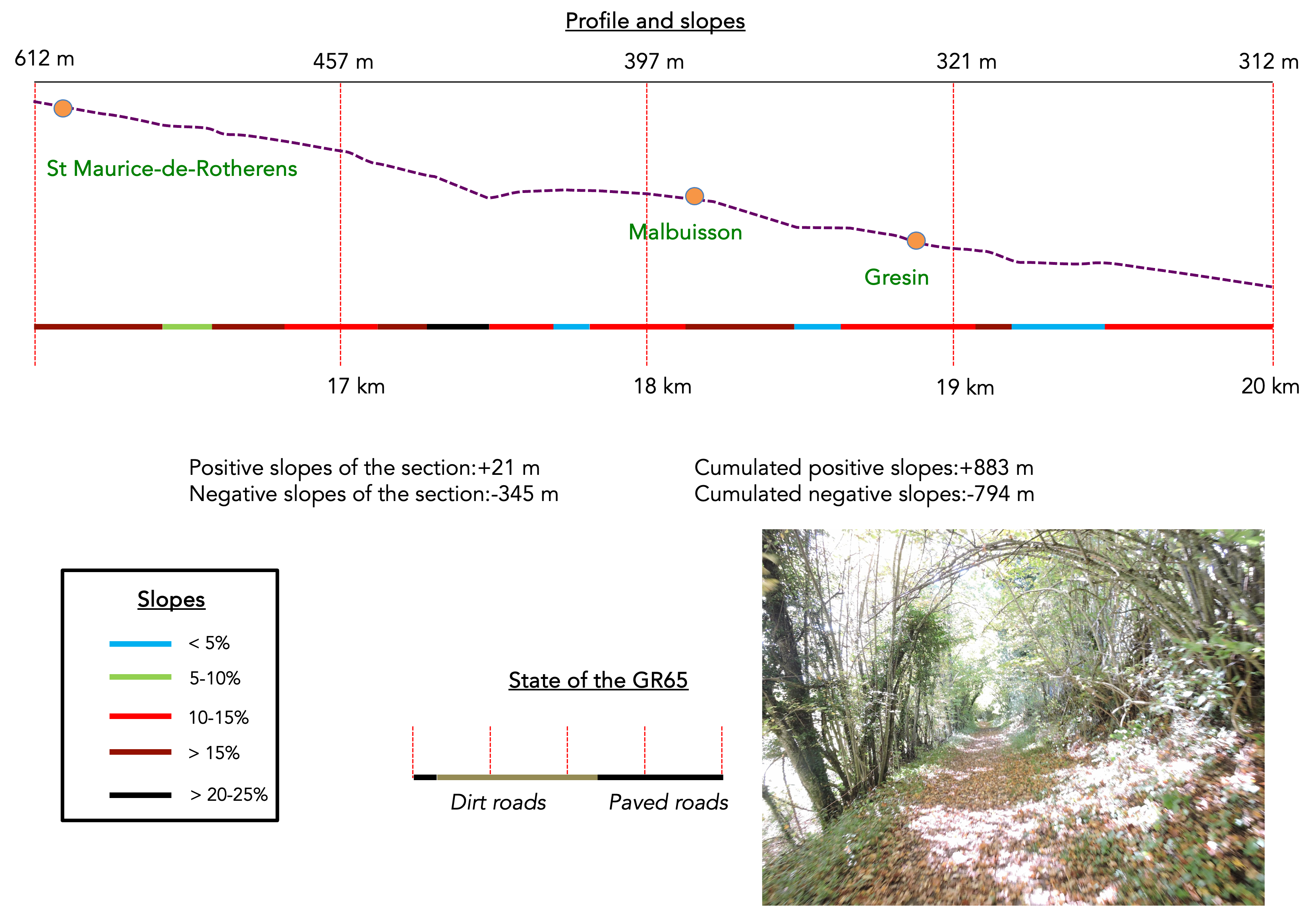
Upon arriving in the village, you learn that two GR trails pass through here, the GR65 and the GR9, and you have been walking for nearly five hours since Yenne. Quite a trifle, isn’t it? Despite being tired, hikers often find comfort in talking with the locals who, with a kind smile, share anecdotes and local stories.

|
In St Maurice-de-Rotherens, a small village of about 250 souls, you discover a few scattered farms, a picturesque church, the town hall, and a charming museum dedicated to radio, reflecting a local passion for waves and communication. However, for those seeking to dine, the village offers few options. This is the sad reality of many small villages in France, where the closure of local businesses signifies an inexorable decline. The tranquility of the place contrasts with this desertification of services, offering a sense of melancholy.
|
 |
 |
| The trail then plunges into the undergrowth of Sous La Roche, running through hornbeams and small chestnut trees, intertwined with wild grasses. In this serene and enchanting undergrowth, the constant murmur of the stream below adds a natural, soothing music to the hiker’s soul. However, the slope is irregular, often severe, sometimes exceeding 15%, making the descent technical and demanding, but each step is rewarded by the wild beauty of the place. |
 |
 |
| After a well-deserved break in the meadows, the trail resumes with the same frenzy under the deciduous trees. Here, the wild chestnut trees, skinny and desperately seeking light, raise their slender stems towards the sky. The quality of the soil in the region does not explain the dwarfism of these trees, as the ashes that grow here reach a reasonable size. But who really understands the philosophy of trees? These sentinels of time seem to whisper hidden secrets, witnessing the incessant struggle for survival in an often-harsh environment. |
 |
 |
| Further down, the trail emerges from the woods, but the slope hardly softens. On the horizon, the vast Rhône valley stretches, linking Chambéry to Lyon. The eye embraces a spectacular panorama where the grandeur of the mountains mingles with the softness of the plains. |
 |
 |
| The trail continues its descent through the meadows, surrounded by a variety of trees such as sturdy oaks and graceful ashes, almost to the road to Mount Tournier Pass. |
 |
 |
| However, true to the spirit of the Camino de Santiago, which avoids busy roads, an alternative emerges. A wider path slopes up slightly, skirting the edge of the undergrowth, offering a peaceful refuge in the shade of the trees. |
 |
 |
| Soon, the path reaches Malbuisson, a small hamlet nestled under the hill of Sous La Roche. Here, a heath of dry lawns stretches, protected by low foliage that covers the cliffs overlooking the hamlet. This singular landscape evokes an atmosphere of timeless tranquility. |
 |
 |
Leaving Malbuisson, the countryside opens up a bit more. The GR65 barely grazes this hamlet. The walk becomes lighter, carried by the softness of the surrounding landscapes.

Further down, near a finely wrought iron cross, a sign announces that S Genix is 1h50 away from here. After such an epic journey, this proximity seems almost unreal, like a promise of well-deserved rest after such an ordeal.

|
The path descends below Malbuisson through the meadows towards Gresin. Once, these lands were adorned with vines and sturdy chestnut trees, but today, they are dominated by lush meadows and some corn crops. On the horizon extends the Côte Envers, towards which the route heads, promising a landscape that unfolds step by step. On the left, the road descends from Tournier Pass, suggesting other routes and adventures extending beyond.
|
 |
 |
|
Descending towards the church, you will see on your right two remarkable fortified farms, locally known as Grosses Maisons. The first, La Tour, erected in the 16th century, stands proudly with its multiple buildings that tell the story of centuries of rural life. Next to it is the farm of La Maréchale, another testimony to the bourgeois architecture of the region, offering an imposing and authentic vision of past agricultural life.
|
 |
 |
|
The church, illuminated by a slightly too bright light, betrays its more recent construction, dating from the 19th century. Yet, despite its relative youth, it harmoniously integrates into the surrounding landscape.
|
 |
 |
The kindergarten, although dating from the 19th century, has seen its facilities expanded over the years to joyfully accommodate all the valley’s toddlers. It is a vibrant place of laughter and learning, where echoes of youth resound. However, for those hoping for a picnic along the way, it is a total disappointment. Between Yenne and St. Genix, there is nothing to eat except for the grandiose landscape that stretches as far as the eye can see.
. |
 |
 |
| However, to quench your thirst, a water point is available at the toilets, and just below Gresin.
A magical stop awaits pilgrims eager for rest and contemplation. Almost all stop there, drawn by the opportunity to write a few thoughts in the logbook, savor a coffee, a syrup, or a cold drink, as if a moment suspended in time. |
 |
 |
| From here, a stage that has crossed remarkable landscapes becomes more ordinary, as you sometimes encounter on the Camino de Santiago. The GR65 joins the departmental D916 road, following the valley of Côte Envers before climbing the road. |
 |
 |
| It continues its way to the place called Bordet, where it turns towards Côte Envers. The descent then begins gently on a small road, first through fruit orchards, then into the undergrowth that gradually opens towards the river. |
 |
 |
Section 6: The GR65 rejoins the Rhône plain

Overview of route’s challenges: Just one more little hill, ladies and gentlemen!
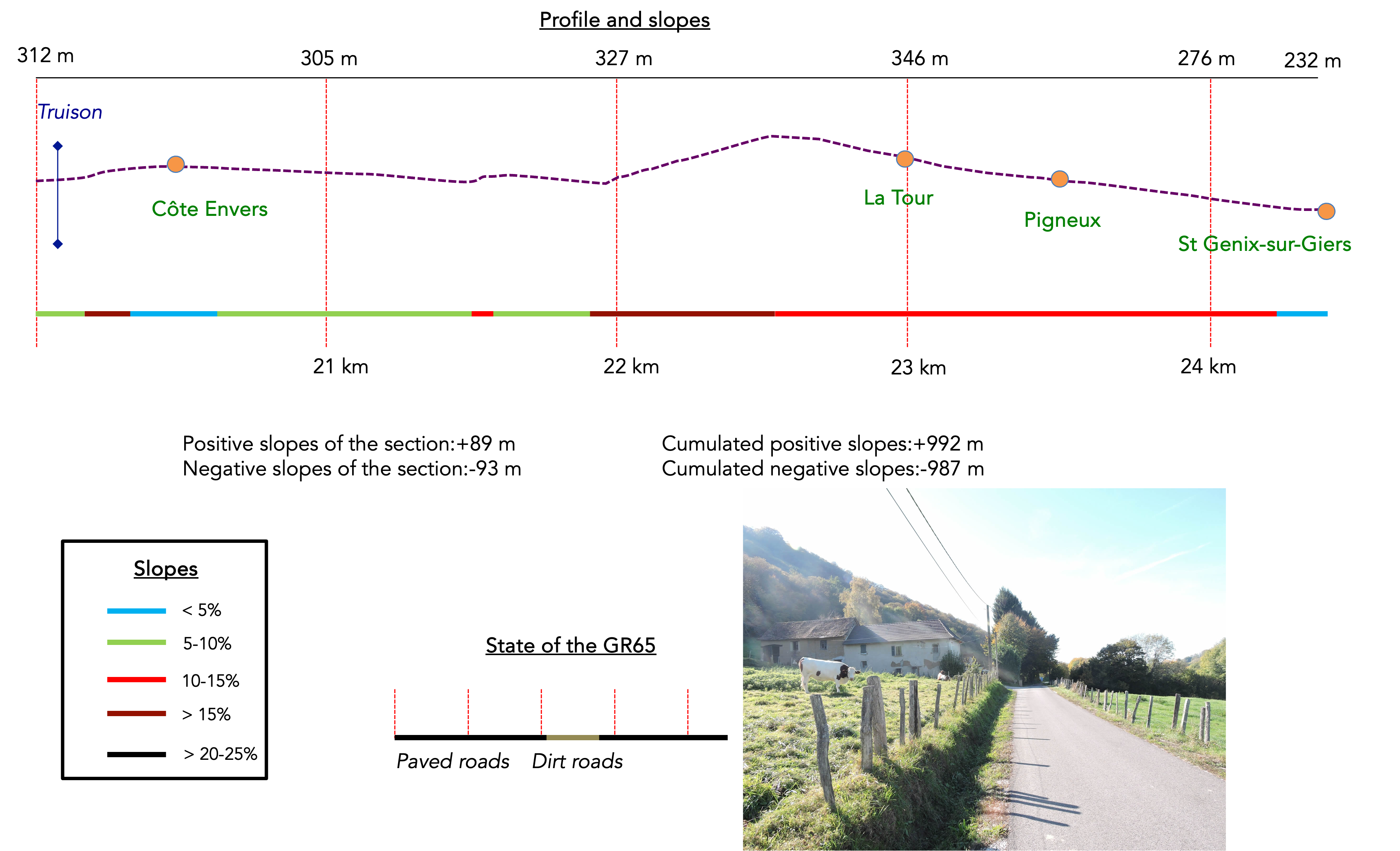
| After crossing the Trison brook, the road climbs up the other side of the dale, winding through deciduous trees. Here, chestnut trees reign supreme, and in autumn, every step resonates with the cracking of fallen leaves and split husks underfoot. |
 |
 |
| The road continues to climb until it reaches the beautiful Côte Envers guesthouse, constructed entirely of pisé, a traditional material that will also be encountered in the next stage, in Dauphiné. |
 |
 |
At this point, St Genix-sur-Guiers is signposted as an hour’s walk away, with the Pas de l’Âne only fifteen minutes off, providing valuable markers for hikers gauging their time and distance.

| For almost a kilometer, the road stretches flat, skirting the woods along Côte Envers. Despite the presence of the road, nature retains an undeniable bucolic charm here. Occasionally, cattle graze peacefully in the meadows, and from time to time, a traditional house stands proudly by the roadside. |
 |
 |
| Soon after, the road plunges back into the woods, under the canopies of slender, towering deciduous trees. |
 |
 |
At the road junction of the Pas de l’Âne, the GR65 invites you to take a trail that dives into the woods. Do not expect a grand panorama here, but rather an immersion into woodland tranquility. However, the presence of the GR65 at this location indicates it also leads to the Pigneux chapel, perched above St Genix-sur-Guiers. Thus, depending on your energy and curiosity, you can choose to continue on this rustic trail or follow the direct road to St Genix.

| For the daring souls or those faithful to the tradition of routes forged by past generations – a naive notion of the Camino de Santiago devotees – the trail resolutely climbs through the woods, where the autumn leaf carpet crunches underfoot. |
 |
 |
| On slopes ranging from 10% to 15%, the trail winds through the dense deciduous forest. Here and there, you can discern the discreet presence of oaks, ashes, and maples, blending into the natural disorder of the woods. |
 |
 |
| Nevertheless, it is the sparse chestnut trees that still dominate the landscape, forming diffuse groups, sometimes resembling organized battalions, evoking a skeletal army on the march. The Ardèche is often cited as the land of chestnuts. Indeed, there, the chestnut trees are mainly grafted trees, which is extremely rare here. |
 |
 |
The climb, though demanding, ends as the path exits the woods, suddenly opening onto the small plateau of the place called Le Vuillerot, offering a welcome respite after the sustained effort.

| The GR65 then makes its way across this modest plateau, where the green meadows and scattered crops testify to human activity in harmony with the surrounding nature. |
 |
 |
| At the crest’s point, the path begins its descent towards the plain. From up there, the view stretches over St Genix and the vast Rhône plain, a panorama that, while sweeping, may not inspire overwhelming enthusiasm in hikers accustomed to the more intimate beauties of paths lost in secret nature. |
 |
 |
| Exiting a dense undergrowth, the GR65 reconnects with tarmac at the entrance of the hamlet of La Tour, enveloped by the greenery of the trees. The ensuing descent is quite steep. |
 |
 |
| The road then winds through Pigneux, where modest villas rise above St Genix, testifying to a simple and authentic life in this rural setting. It finally joins a departmental road descending towards St Genix. |
 |
 |
| The Pigneux chapel stands along this road, near the cemetery. Let us not be stingy with compliments towards the planners of the Camino de Santiago: this sacred building is remarkably beautiful and attracts many faithful. Moreover, it remains open to visitors, inviting contemplation and prayer. According to legend, this chapel was dedicated in the 7th century to the Virgin, in gratitude for a victory against the Moors, although historical details are shrouded in mystery. Originally in ruins by the late 18th century, it was expanded and restored several times, until a complete renovation in 2001 restored its original splendor. |
 |
 |
| The GR65 then descends along the sidewalk, winding under grafted chestnut trees and shaded ashes, until it reaches the heights of the small town. |
 |
 |
St Genix-sur-Guiers, home to about 2,500 inhabitants, is imbued with a rich and tumultuous history. Strategically located, it was the scene of endless disputes between the lords of Savoy and Dauphiné over the centuries. Once a fortified town with a castle and ramparts, it has lost its defenses, except for a gate and a few remnants of its old walls.

| Positioned at the border between Savoy and Isère, it marks this boundary with the bridge crossing the Guiers, a river emblematic of the region. |
 |
 |
| Its historic center, concentrated around the church, still retains today magnificent stone or pisé houses, witnesses of a glorious past. St Genix is also famous for its eponymous cake. According to legend, the Saint Genix cake owes its origin to Saint Agatha, a Sicilian martyr who, refusing to renounce her Christian faith, had her breasts cut off. They miraculously grew back overnight. After Sicily’s annexation to Savoy, women began to make a breast-shaped cake. In the mid-19th century, Françoise Guillaud, originally from Les Abrets in Isère, married hotelier Pierre Labully in Saint Genix and brought the recipe for a brioche. In 1880, he had the idea of adding pralines inside. The cake was an immediate successt. |
 |
 |
| Churches have succeeded each other here since the 11th century, formerly associated with a now disappeared monastery. The current church, erected in 1861, testifies to the community’s architectural and spiritual evolution over the centuries. |
 |
 |
Official accommodations on the Via Gebennensis
- Accueil randonneur Mauchamp, 30 Rue Victor Hugo, Les Abrets; 06 99 08 83 37/ 05 76 55 42 32; Gîte, dinner, breakfast
- Cntre AMATA, 99 Chemin de Brézin, Valencogne; 04 37 05 29 33; Guestroom, dinner, breakfast
- Les Balcons du Lac, Ars, Lac Paladru; 04 76 06 64 00/04 76 06 68 82; Guestroom, dinner, breakfast
- L’Echo Pin, Le Pin; 06 75 9770 32; Guestroom, breakfast
Pilgrim hospitality/Accueils jacquaires (see introduction)
- Romagnieu (1)
- Les Abrets (1)
- Valencogne (3)
If one takes inventory of the accommodations, lodging presents a serious problem on this stage if you go all the way to the end, with one accommodation at Lake Paladru and another at Le Pin. Certainly, there are plenty of places to stay along the route, outside the path, in Charencieu near Les Abrets, on the outskirts of St Ondras, or at the end of Lac de Paladru, in Charavines. Restaurants in Les Abrets, Valencogne, and Le Pin. For more details, the guide of the Friends of Compostela keeps a record of all these addresses, as well as bars, restaurants, or bakeries along the route, and outside of it.
Feel free to add comments. This is often how you move up the Google hierarchy, and how more pilgrims will have access to the site.
|
 |
Next stage : Stage 6: From St Genix-sur-Guiers to Lake Paladru |
|
 |
Back to menu |


