
To open the map, click in the rectangle at the top right. It is an interactive map that allows you to visualize this route in the context of France. The circles correspond to the end of each stage. By clicking on these circles, you will have access to the information that Google gives for these places (images, some accommodations, routes, etc.). It could also help you sometimes, even if this information is more for people who drive around, not on foot, like you …..
Here are the stages from Basel to Cluny. Click on the stages to open:
Stage 04: Héricourt to Villers-sur-Saulnot
Stage 05: Villers-sur-Saulnot to Villersexel
Stage 06: Villersexel to Filain
Stage 10: Marnay to Acey Abbey
Stage 11: Acey Abbey to Mont Roland
Stage 12: Mont Roland to St Jean-de-Losne
Stage 13: St Jean-de-Losne to Citeaux Abbey
Stage 14: Citeaux Abbey to Vougeot
Stage 18: Givry to St Gengoux-le-National
Stage 19: St Gengoux-le-National to Cluny
You can either enter at the step of your choice or follow the navigation from one step to the next. Have a good journey.
Route of Franche-Comté and Burgundy / Route to Cluny / Le Puy-en-Velay
From Basel to Cluny
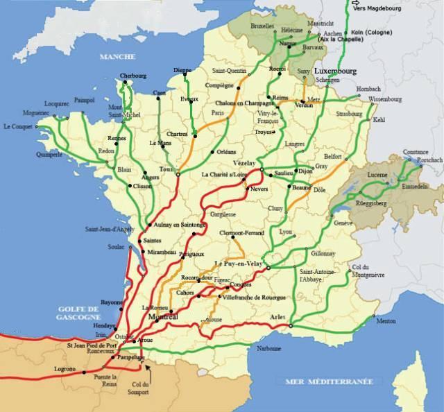
There are several routes from Germany, Switzerland, or the countries of Eastern Europe that lead to Le Puy-en-Velay, which many people mistakenly consider to be the starting point of the Way of St. James, although it is in fact the most traditional gathering place for pilgrims to Santiago in France. Since Switzerland is something of a European crossroads, many pilgrims, especially those from German-speaking countries, generally arrive in Basel. Others arrive farther north via Strasbourg, or farther south via Freiburg. Still others come by way of Lake Constance and cross Switzerland along the Via Jacobi as far as Geneva. From there, they follow the Via Gebennensis to reach Le Puy-en-Velay.
The Via Jacobi and the Via Gebennensis are covered in other chapters on this website. Here, we describe the route that leads to Le Puy-en-Velay from Basel. At first, it is a connecting spur that links up with the routes from Northern Europe, near Belfort, shortly after Héricourt. From Héricourt onward, the route crosses Franche-Comté and Burgundy to reach Cluny, the cradle of the Benedictine order. From Cluny, the route continues into the Haute-Loire, reaching Le Puy-en-Velay.
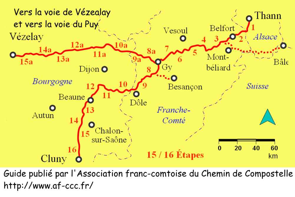
Route of Franche-Comté and Burgundy / From Basel to Cluny
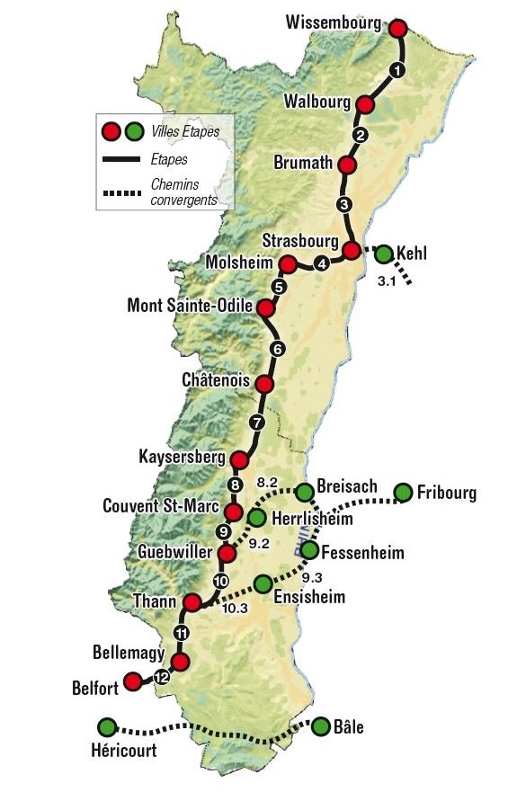
The first part of the journey therefore takes place between the Haut-Rhin in Alsace and Switzerland, in Basel. You will need to look elsewhere for information on how to find your way to this point. The first three stages wander between France and Switzerland, often straddling the border, along a route that frequently passes through beautiful forests before becoming more settled along the magnificent Rhône–Rhine Canal. Shortly beyondr Héricourt, the Basel spur joins the routes coming down from the northeast. This is followed by a fairly long crossing of the Haute-Saône département. The landscape is made up of gentle hills and meadows with little cultivation. While the countryside is often monotonous, the forests are a real delight. Gy is the hub of the routes in this region. It is here that the choice is made between the two major itineraries of the Way of St. James in France: the choice between Vézelay or Le Puy-en-Velay. This must be stated clearly. Many German-speaking pilgrims will favor the Vézelay route. German and Eastern European pilgrims who wish to walk through Le Puy generally prefer to cross Switzerland to Geneva and then reach Le Puy-en-Velay via the Via Gebennensis.
From Gy onward, the route heads down toward Dole and then crosses the Burgundy wine-growing region on its way to Cluny.
The Associations of Friends of the Way of St. James in Alsace, Franche-Comté, Burgundy, and Switzerland publish a small guide devoted to this route, entitled The Way of St. James: Thann–Cluny, Basel–Vézelay. To our knowledge, this is the only guide available for this itinerary. Without wishing to disparage the authors, who have carried out remarkable and substantial work in waymarking these routes, it must nevertheless be said that reading and following the routes in their guide is not easy. In this region, routes abound, marked with circles, triangles, rectangles, or diamonds in every color imaginable. Unfortunately, the scallop shell of St. James, the best marker of the Way of St. James, is often missing. As a result, it is very easy to lose one’s way in this confusing maze of local paths. There is also, regrettably, another major problem: the waymarking is difficult and often imprecise. The scallop shell is rarely placed correctly; only the directional arrow can generally be relied upon. and even then, not always.
For this reason, in order to make your journey easier, this guide points out all the intricacies and traps that could lead you astray. On the other hand, the guide published by these associations is quite essential for finding accommodation, both on and off the route.
How do pilgrims plan their journey? Some imagine that simply following the waymarks will be enough, but you will soon discover to your cost that the signage is often inadequate. Others rely on guides available on the Internet, which are also often too basic. Some prefer to use GPS, provided they have imported the Compostela maps for the region onto their phone. Using this method, if you are proficient with GPS, you will not get lost, even if the route suggested is sometimes not exactly the same as that indicated by the scallop shells. Nevertheless, you will still reach the end of each stage. In this regard, the site generally considered “official” is the European route of the Ways of St. James (https://camino-europe.eu/). For most stages, the maps are accurate, but this is not always the case. With a GPS, it is even safer to use the Wikiloc maps that we make available, which describe the currently waymarked route. However, not all pilgrims are experts in this type of navigation, which some feel detracts from the spirit of the Way. In that case, you can simply follow us and read our guide. Every difficult junction or confusing point along the route has been identified to help you avoid getting lost.
Route Waymarking
If you have already walked on long-distance hiking trails in France (GR routes), you know that direction is indicated by the red and white GR markings.

On these GR routes leading to Santiago, you will also always find waymarking that uses the famous Compostela scallop shell, yellow on a blue background.
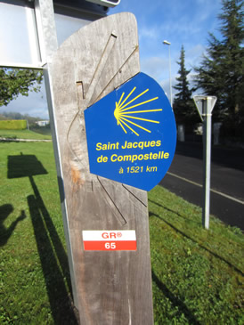
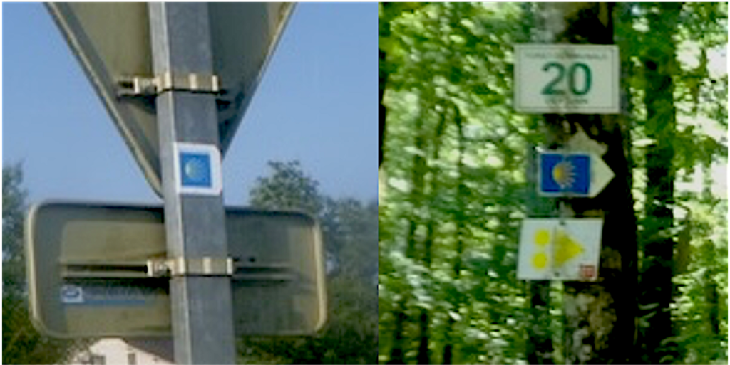
In Burgundy and Franche-Comté, however, you are not walking on a GR trail, or only very rarely. As a result, the scallop shell is often the only guide available to you, apart from the bewildering array of symbols of all shapes and colors used by regional routes. Most of the time, the shell is there only to indicate that you are on the Way of St. James. You should never rely on its orientation, as you would on the GR65 from Le Puy-en-Velay. If you have walked on the GR65, you know that when the heart of the shell points to the left, that is always the direction to follow. Here, this is not the case. In the two examples shown, both directions lead to the right. Why? Because it is the white arrow placed next to the shell that indicates the direction, not the shell itself. You can easily imagine the confusion this creates. In the image on the left, the white arrow has been cropped or badly affixed. Yet the route still goes to the right. This is why, on this website, we guide you step by step, a ork that should have been done more carefully by the French Friends of the Way of St. James.
Important note on distance and elevation
It is very difficult to specify route gradients with certainty, regardless of the system you use, whether GPS watches or mapped elevation profiles. There are very few websites on the Internet that can be used to estimate gradients (three at most). Since these programs are based on approximations and averages around a given point, there can be large variations from one software program to another, due to differences between two points (for example, a dip followed very closely by a rise). An example? On the GR36 along the Breton coast, the altitude is rarely more than 50 meters above sea level, yet the route keeps going up and down all day long. For a route of about twenty kilometers, one program will show 800 meters of elevation gain, another 300 meters. Who is telling the truth? Having done the route several times, my legs say that the elevation difference is closer to 800 meters! So how do we proceed? We can rely on software, but we must remain cautious: average the data, ignore the gradients provided, and consider only the elevations. From there, it is simply basic mathematics to deduce the gradients, taking into account the altitude and the distance covered between two points with known elevations. This is the method used on this site. Moreover, in hindsight, when you “estimate” the calculated route based on mapping, you will notice that this approach is quite close to the reality on the ground. When you hike often, you quickly develop a sense of slope, especially in your legs.
There is more to it. Programs that calculate elevation gain lack precision for relatively flat routes, often failing to take into account small variations of less than two meters. As a result, especially for sections with less than a 5% gradient, you may feel that it is almost flat, but this is not always correct. The trail may go up and down frequently in ways that are barely perceptible. However, your legs register all of these movements. So, to be closer to reality, add 100 to 200 meters of positive and negative elevation gain for most of these stages. Some GPS watches that continuously record your track will tell you the same thing. But here again, GPS is not as precise as a Swiss watch. It is easy to understand the difficulty of the exercise. Having tested this several times with two different GPS devices that also provide altimetry, one can sometimes find significant differences in the indicated altitude. The only truly reliable figures are those given by the contour lines on official state maps. But this should in no way spoil your enjoyment, even if the figures provided are approximate, though likely quite close to the reality of the terrain.
In the graphs, simply pay attention to the color to understand what it represents. Light colors (blue and green) indicate moderate slopes of less than 10%. Bright colors (red and dark brown) show steep slopes, with brown exceeding 15%. The steepest gradients, over 20–25%, very rarely more, are marked in black.
Accommodation and the Issue of “Accueil Jacquaire” (Pilgrim Hosting)
Our information was updated in 2024. You should be aware that accommodation options along these routes are more limited than on the Via Podiensis. Such a list can never be exhaustive. Each year, some establishments close while others open. For these routes, there is no pilgrims’ “bible” like Miam Miam Dodo, which is so widely available on most other routes to Santiago. The only French-language guide is the small booklet published by the Association des Amis de Saint-Jacques, entitled “Chemin de Saint-Jacques – Alsace–Franche-Comté–Bourgogne”, which you can find online. The most common type of accommodation is the gîte (hostel), which offers more conviviality and a significantly lower price. These gîtes may have only one shared kitchen, though most of them serve breakfast and sometimes dinner as well. Guesthouses (chambres d’hôtes) and hotels are preferred by pilgrims who struggle to rest in gîtes due to the unavoidable snoring in shared dormitories.
On these routes, a distinctive feature is the presence of many “accueils jacquaires,” where prices are left to the pilgrim’s discretion. On the Camino de Santiago, pilgrims use various types of accommodation: gîtes, hotels, guesthouses, or “accueils jacquaires”. These are listed online through specialized platforms or indicated by signage along the trail. In general, accommodation providers are subject to the same obligations as traditional lodging businesses, including declaration at the town hall and taxation of income derived from hosting activities. The case of hosts operating under the Donativo system, that is “accueil jacquaire” based on a voluntary contribution in exchange for lodging and meals, must be considered as follows: If the host provides services free of charge or almost free (for example, suggesting only a symbolic amount unrelated to the value of the service), then the same obligations as those applied to the traditional lodging sector should not be required, since it cannot be considered a commercial activity. If the host accommodates a pilgrim in exchange for financial participation, regardless of the amount, then the host must comply with the regulations and obligations governing traditional accommodation, as regulated by the Tourism Code. In this case, the host must inform the pilgrim of the price in advance, make the necessary declarations to the town hall, and declare income to the tax and social authorities.
What does the law really say? Very little. Everything remains vague. It is clear that the world of “accueils jacquaires” has sometimes drifted away from its original generous spirit. Here is what was known in 2018. Some people divert the principle of “accueil jacquaire” from its original meaning, which is to offer hospitality in one’s home free of charge. These “accueils jacquaires” are publicly listed in gîte and guesthouse guides. They host increasing numbers of pilgrims, tourists, and travelers regularly and for payment. This hospitality has a price, often with different rates per night depending on whether breakfast is included, though the price is, of course, not officially displayed. However, since “accueil jacquaire” does not constitute a guesthouse rental within the meaning of Article L. 324-3 of the Tourism Code, it is not subject to the declaration requirement at the town hall provided for in Article 324-4 of the same code. It therefore escapes official control. As it is theoretically an occasional and free form of hospitality, it is not subject to regulatory compliance standards. It also escapes any tax regime. Without challenging the principle of Donativo, the question arises whether “accueil jacquaire” should be more clearly regulated to prevent the development of unfair competition.
It is ultimately a matter of honesty, either on the part of the host or the guest. Having frequently used this type of accommodation and discussed it with hosts, in most cases pilgrims pay roughly the equivalent of what they would pay elsewhere in a guesthouse. However, hosts have no obligation to inform you whether they declare or do not declare the donation made by the pilgrim.
In their booklet about the route, the Amis de Compostelle state that the contact details of “accueils jacquaires” must not be shared. From the documents available online, we cannot determine the validity of this position, and many guides go beyond this restriction. However, we do not wish to undermine the Amis de Compostelle, of which we are also members. Therefore, we will not publish these addresses, even though they are very useful given the limited official accommodation available. You may of course set out on your journey without reservations and find lodging along the way. But this can be difficult at certain stages. Along the entire route, it is advisable to book in advance, as accommodation is limited and not always open. And if you prefer to avoid uncertainty, purchase the Amis de Compostelle booklet.
 |
To start the route in Basel |