In “Ardèche Plein Cœur”
DIDIER HEUMANN, ANDREAS PAPASAVVAS
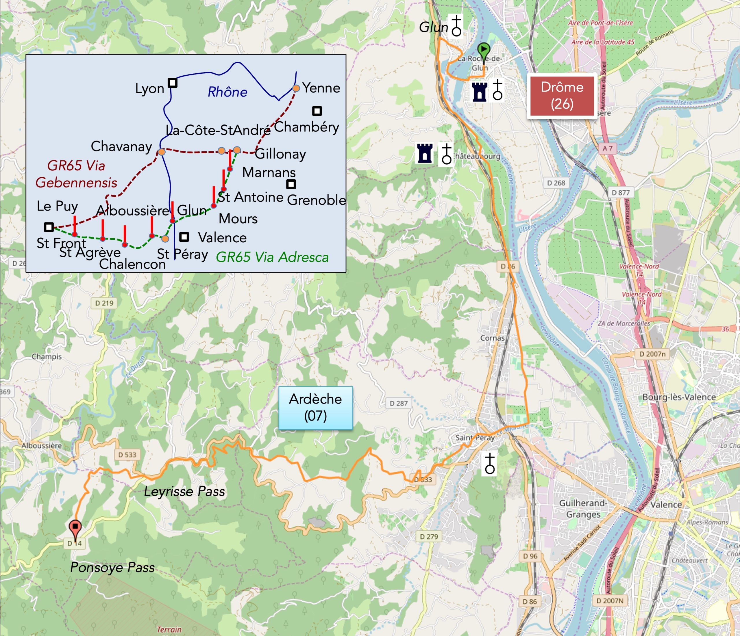
We divided the course into several sections to make it easier to see. For each section, the maps show the course, the slopes found on the course, and the state of the route (paved or dirt roads). The courses were drawn on the « Wikilocs » platform. Today, it is no longer necessary to walk around with detailed maps in your pocket or bag. If you have a mobile phone or tablet, you can easily follow routes live.
justify; »>For this stage, here is the link:
https://fr.wikiloc.com/itineraires-randonnee/foriel-auvergne-rhone-alpes-france-32920711
| Not every pilgrim feels comfortable using GPS devices or navigating on a phone, especially since many sections still lack reliable internet. To make your journey easier, a book dedicated to the Via Gebennensis through Haute-Loire is available on Amazon. More than just a practical guide, it leads you step by step, kilometre after kilometre, giving you everything you need for smooth planning with no unpleasant surprises. Beyond its useful tips, it also conveys the route’s enchanting atmosphere, capturing the landscape’s beauty, the majesty of the trees and the spiritual essence of the trek. Only the pictures are missing; everything else is there to transport you.
We’ve also published a second book that, with slightly fewer details but all the essential information, outlines two possible routes from Geneva to Le Puy-en-Velay. You can choose either the Via Gebennensis, which crosses Haute-Loire, or the Gillonnay variant (Via Adresca), which branches off at La Côte-Saint-André to follow a route through Ardèche. The choice of the route is yours. |
 |
 |
If you only want to consult lodging of the stage, go directly to the bottom of the page.
The Upper Vivarais, on the edge of the Massif Central, is a juxtaposition of small plateaus at moderate altitude and hills that rise up to nearly 800 meters above sea level. Since the basic structure of the Massif Central is granite, with flows of volcanic basalt, the region is mostly granite, but also includes gneiss, which is a transitional product of granite. In the coming days, the volcanic mountains of Ardèche will begin to appear on the horizon, stretching towards the Haute-Loire Department. You are walking these days, and indeed along the majority of the Via Adresca in the “Ardèche Plein Cœur,” which refers to the central part of the department, situated neither in the north nor the south. You walked through part of it yesterday, as this region extends from the Rhône Valley, near St Péray, to Mount Mézenc, at the boundary with Haute-Loire at the other end. In fact, it is a sort of high plateau, cut by deep rivers to the north and south, but also often from one plateau to another. Here, meadows, rarely orchards, are found alongside pines, maples, oaks, and above all chestnut trees, often passing from the gentlest slopes to very steep inclines. You will encounter thousands of chestnut trees, some several centuries old, each more majestic than the other. And to think that this marvel once suffered a decline. Today, it is claimed that they are on a comeback, just like the good old days when the tree covered the entire country. At least, the Ardèche chestnut has now become an AOC (Appellation d’Origine Contrôlée). Long life to the chestnut farmers!
Today, the Via Adresca, the Compostela trail, merges with the GR42/420. From now on, you can easily follow the red and white marks of the GR, or the scallop shell of Compostela. But here’s a tip: always follow the scallop shells, as the routes here often diverge from one day to the next. You will finish the day in a haven of happiness, the village of Chalencon, perched on the hill, where peace reigns and where it’s a joy to breathe in the old stones in the shadow of the winding alleyways.
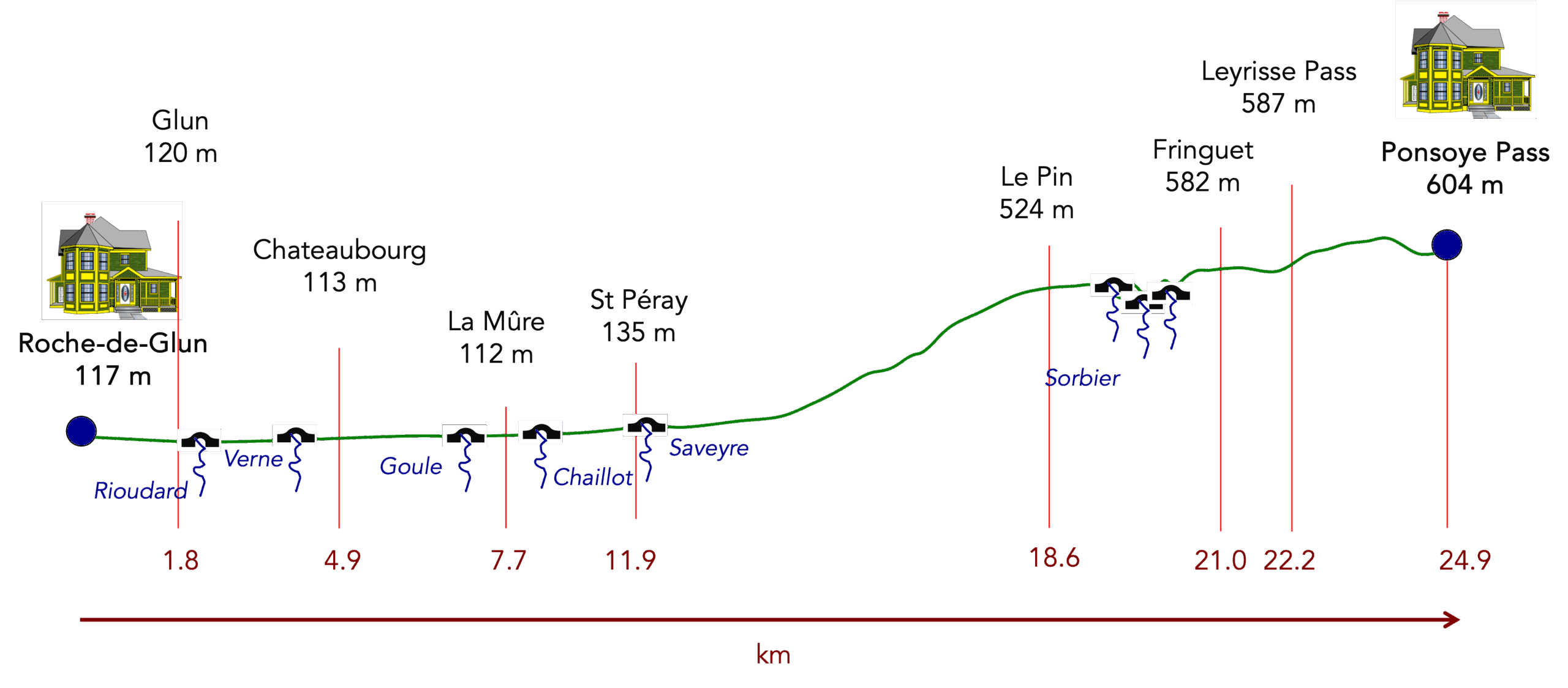
Difficulty level: The elevation changes (+610 meters/-530 meters) are quite significant for a 20-kilometer stage. This is another tough stage, as is typical in the Vivarais, but it’s part of the pleasure of walking in these regions. There’s first a continuous climb to the Herbasse, followed by a long descent into the forest towards Savinas. From there, it’s necessary to descend to the bottom of the valley before climbing back up to Vernoux-en-Vivarais, the main town of the region located on a plateau. Then, it’s again a rollercoaster of ups and downs to climb to Chalencon, perched on the hill.
State of the Via Adresca: Today, the advantage goes to paths over roads:
- Paved roads: 7.3 km
- Dirt roads : 12,9 km
Sometimes, for reasons of logistics or housing possibilities, these stages mix routes operated on different days, having passed several times on these routes. From then on, the skies, the rain, or the seasons can vary. But, generally this is not the case, and in fact this does not change the description of the course.
It is very difficult to specify with certainty the incline of the slopes, whatever the system you use.
For those seeking « true elevations » and enthusiasts of genuine altimetric challenges, carefully review the information on mileage at the beginning of the guide.

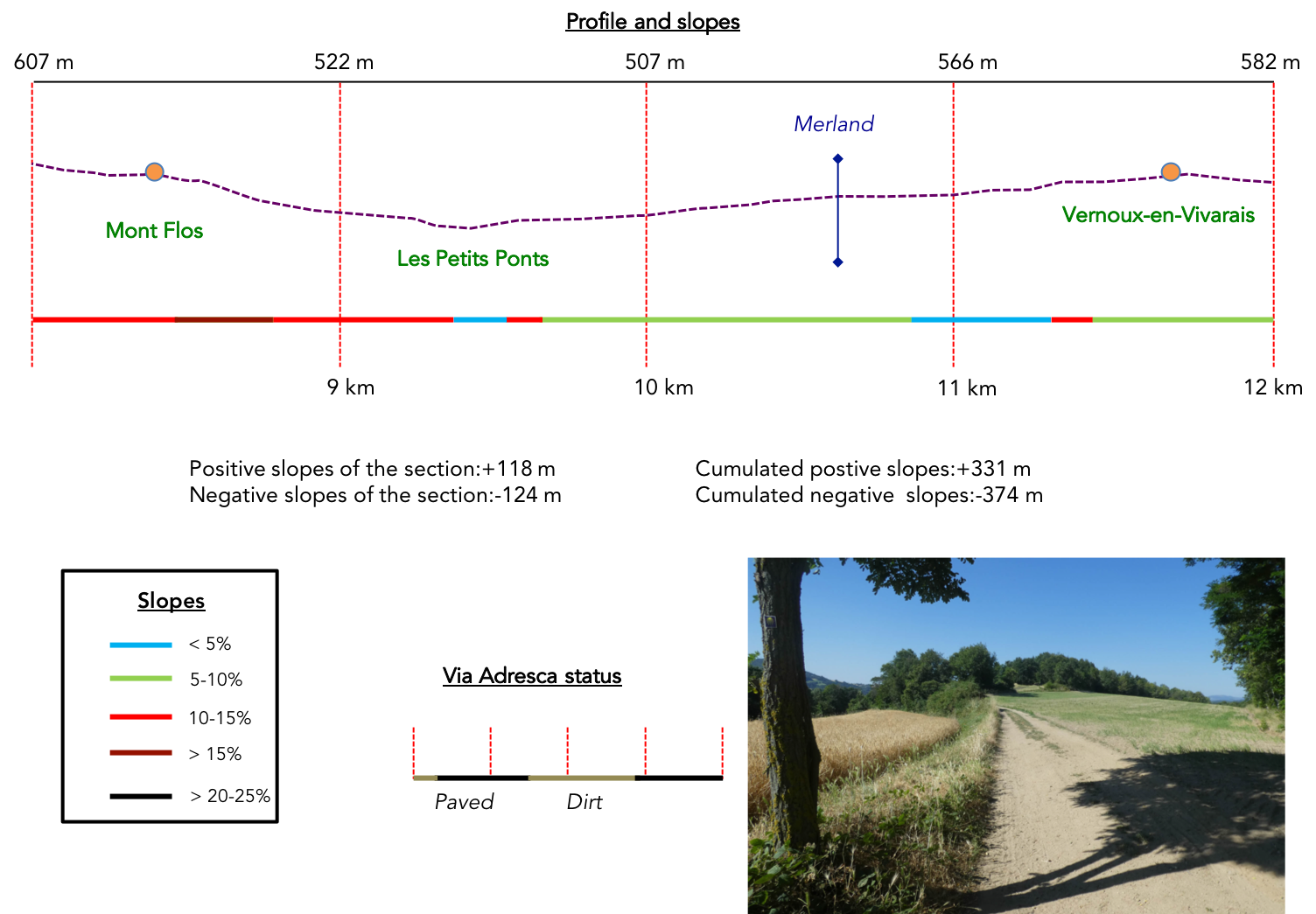
Section 1: Ups and downs in forests and glades

General overview of the difficulties of the route : course which is not easy, with sometimes marked slopes, close to or more than 15%.

| If you stayed overnight in one of the two accommodations nestled in Cerisier, you need to backtrack along the paved road that leads back to the Ponsoye Pass. |
 |
 |
| There, a dirt path begins its climb up the hill, bordered by enchanting nature. This path, scattered with stones, soon leads to the heart of a dense forest where small chestnut trees stand as silent guardians, aligned like ranks of a motionless army. In this place where light barely filters through, the air feels cooler, almost solemn. Here, the slope becomes steeper, a challenge for hikers. |
 |
 |
| Higher up, the landscape resumes the same wild character as the day before. You cross an untamed world, punctuated by tangled bushes, robust green oaks, and ash trees with elegant branches. Nature reigns supreme here, offering a scene filled with simplicity and strength. The path eventually opens into a clearing where the place called Le Cerisier is located. |
 |
 |
| Here, the calm is almost tangible, and in the distance, the village of Boffres can be seen. The paved road winding from the Ponsoye Pass leads there gently, while below, the accommodations in Cerisier are discernible above the village of Alboussière, nestled in a lush green hollow. |
 |
 |
| The direction to follow is now L’Herbasse, three kilometers away. A narrow trail weaves through a magnificent heathland, a living tableau of golden broom, gnarled junipers, and wild grasses swaying with the wind. The ochre and loamy soil, almost sandy, seems to vibrate underfoot, while the scent of wild plants intoxicates the air. |
 |
 |
| Climbing higher, the trail gradually leaves this heathland behind and plunges into a darker forest. |
 |
 |
| Here, the chestnut trees assert their majestic presence, their sturdy trunks forming an almost impenetrable barrier. They dominate this part of the Ardèche, leaving little room for other species. These trees, true monarchs of the area, give the forest a singular aura, both protective and mysterious. |
 |
 |
| Then, a wider path escapes the forest and begins its descent on the other side of the hill. In places, large stones litter the path, making the progress slightly uneven but never unpleasant. The landscape then opens onto a bucolic scene: the small hills of Ardèche stretch to the horizon, resembling waves frozen in time. They succeed each other, wooded and serene, wrapped in an almost unreal tranquility, as if forgotten by the world’s tumult. |
 |
 |
| The path crosses a small paved road before continuing, hesitating, wavering between a slight ascent and subtle detours. |
 |
 |
Here, the traveler, amidst peaceful grazing herds, discovers a breathtaking view. The village of Boffres reappears, crowned by its church and tower, remnants of another era, proud and immutable.

| Soon, the path dives into a tangle of bushes, winding its way to the Croix Saint-André. There, a Jacobean welcome awaits pilgrims, true to the hospitable nature of the place. But it is wise not to leave things to chance: it’s better to call ahead to reserve on the Via Adresca, this ancestral route, and avoid any unpleasant surprises. |
 |
 |
| The Via Adresca gently descends along a small departmental road. Yet here, the rare vehicles seem to belong to another world. These remote regions have a serenity that is almost unsettling, where humans have left few traces. |
 |
 |
On the horizon, the gaze is drawn to the forests, which boldly climb the hills. The treetops, dotted with wind turbines, testify to a surprising coexistence between modernity and wild nature. There are still so many uninhabited spaces here, places where solitude becomes majestic and silence a companion.

| The paved road eventually slopes gently down, guiding the hiker to a stone house, simple and charming. Next to it, a fountain seems to whisper promises of relief. The fresh water flowing from it invites you to empty a too-warm water bottle and refill it with this revitalizing source. These moments, as rare as they are precious, are gifts for those who venture onto these paths. |
 |
 |
| And more water will likely be needed to face what comes next: a steep trail climbs back up into the Serre de Muans. There, among rugged stones and impassive chestnut trees, the traveler feels the harshness of Ardèche’s untamed land, full of soul yet indomitable. |
 |
 |
Section 2: In the deep forest

Overview of the route’s challenges : mostly downhill, with some steep sections in the woods.
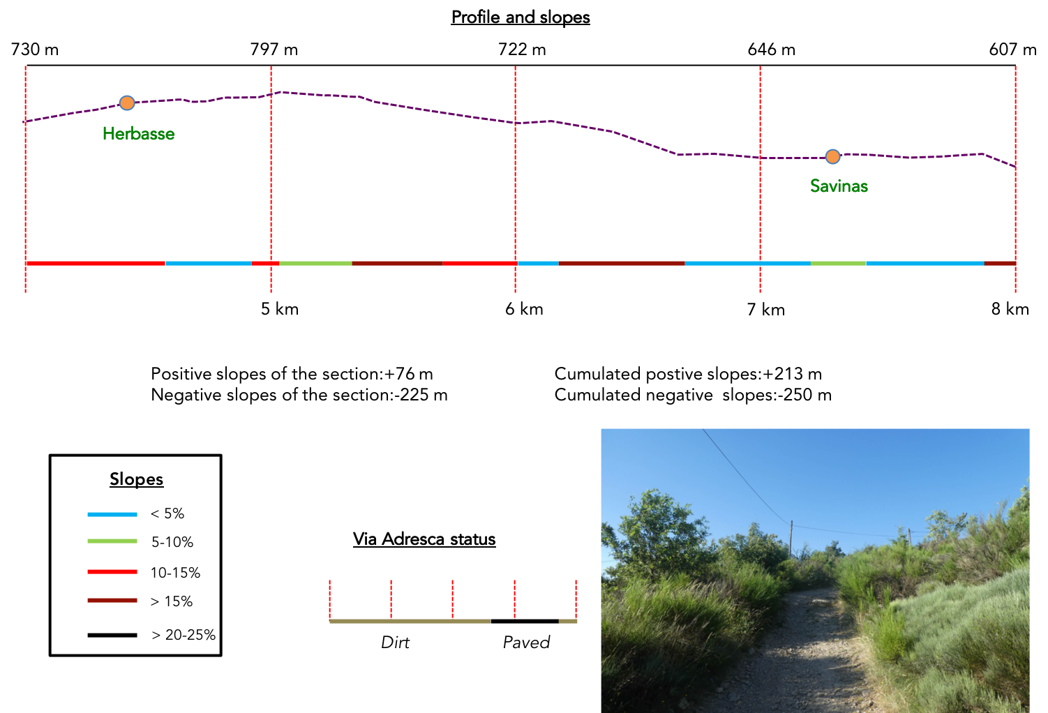
Climbing the slopes of L’Herbasse, the trail demands its toll. The relentless ascent, with its 15% gradient, stretches across a rutted ground where stones and roots intertwine in tenacious chaos. The chestnut trees stand as sturdy sentinels, surrounded by deciduous trees with dense foliage. In places, the abundant broom shrubs add a southern touch to the scenery, a discreet but present reminder of the South.

| When the slope finally relents, it offers a well-deserved respite. The landscape transforms: a heathland stretches out, wild and enchanting, dotted with bushes and broom shrubs, while the slender silhouettes of spruces pierce the horizon. You have arrived at the place called L’Herbasse, a peaceful spot located 8.5 kilometers from Vernoux. |
 |
 |
| The trail then merges into a small dirt road leading to a hamlet, lost in a world apart. Here, everything seems frozen in time, far from human frenzy. A sign invites you to slow down, but one wonders: who would dare to rush in this isolated place, barely visited, where even vehicles seem an anomaly? |
 |
 |
This hamlet, nestled at nearly 800 meters of altitude, emerges like a revelation. It rests at the end of an almost impassable bush trail, an enchanting dead end. The stone houses, timeless and majestic, form a haven on a small plateau, as if the outside world had been left behind.

| A wider path resumes its ascent, plunging into the dense forest of the Serre de Muans. Here, light is scarce, almost absent, and the landscape takes on an almost apocalyptic appearance. A regiment of Douglas fir trees dominates this dark universe. Their gigantic trunks soar toward the sky, culminating in a thin tuft of greenery at the top. These giants, actually a variety of pine, can reach dizzying heights, flirting with 100 meters, and live up to 500 years. Imported from America in the 19th century by David Douglas, an English nurseryman, these majestic trees have occupied this land since their planting a few decades ago, as explained by a friendly local encountered further down. |
 |
 |
| Gradually, the forest retreats, giving way to a more open landscape. The path continues to climb, but the slope becomes gentler. Among the bushes timidly reclaiming their ground, the soil takes on an almost clay-like hue, evoking a raw, vegetal richness. . |
 |
 |
| As the climb progresses, the traditional forest asserts itself once again. Spruces and deciduous trees coexist in natural harmony, enveloping the area in a soothing serenity. Finally, the climb ends at the place called Parpaillon. |
 |
 |
| From here, the path ventures into the Serre de Parpaillon, following the hill’s ridges. It winds through undergrowth of chestnut trees, punctuated by sunlit clearings where, unexpectedly, a bit of wheat grows,like a promise of life in this wild land. |
 |
 |
| The path begins a gentle descent, winding between shaded undergrowth and golden fields. The wheat stalks, stirred by a light breeze, whisper forgotten secrets, while beyond, the undulating hills of Vivarais stretch toward the horizon, like a living tableau in pastel hues. You arrive at the place called Le Gratol, a haven of serenity bathed in the warm tones of late afternoon. |
 |
 |

| Here, special vigilance is required: the main trail seems to follow the hedge, but you must veer off, discreetly crossing behind the wheat and entering the thicket. The slope becomes implacable, brutal, flirting with 15%. The soil, eroded by the passage of time, reveals outcroppings of granite rock, a reminder of the raw, untamed nature of this place. |
 |
 |
| Lower down, nestled in a valley hollow, appears an isolated stone house, imbued with rustic charm. It seems to watch, immobile, over this timeless landscape. On the facade, the scallop shell of Compostela shines discreetly, guiding pilgrims with quiet humility. Yet, at the sight of the entrance, hesitation arises: does the trail truly pass through here? |
 |
 |
And yes, unexpectedly, it does. The owner, fortunately present, greets us with a warm smile and the contagious enthusiasm of people deeply rooted in their land. He begins to tell, his voice blending with the rustling wind, the fascinating history of this region. Long ago, in the middle of the last century, these hills were not covered by dense forests as they are today. As far as the eye could see, only large grafted chestnut trees punctuated the landscape, imposing and solitary, rising majestically to the summits. Then came the idea, seemingly trivial at the time, that chestnut husks could be used for tanning leather. In a blind industrial quest, the trees were felled one after another until none remained. No effort was made to replant, and nature, faithful to its incredible strength, reclaimed the land with silent tenacity. Today, these deep forests you traverse are, in reality, only armies of wild offshoots, sprouting from ancient stumps. In this organized chaos, there sometimes remains, at a bend in the path, a grafted chestnut tree defying time, a relic of a bygone past. The Douglas fir forests, planted at the same time, have thrived, later joined by oaks, beeches, maples, and spruces. Walking here is to traverse an almost perfect illusion—forests that seem ancient, majestic, and timeless. What a paradox, isn’t it, to think all of this emerged in less than a century? Nature, with its extraordinary resilience, has covered humanity’s scars with a mantle of life, creating a new harmony. And yet, today, man strives to right his wrongs. Here and there, young chestnut trees are being replanted, timid but determined efforts to bring the ancestral tree back to its glory. But it will take time, decades, perhaps centuries, for them to one day rival the grandeur of their illustrious predecessors.

| The trail continues its descent, lazily winding between pines and chestnut trees, then occasionally crossing meadows carpeted with wild grasses. The muffled sounds of footsteps on the ground mingle softness and fragility, until a small dirt road appears, modest and discreet, at a turn in the path. |
 |
 |
| Soon, the asphalt emerges, signaling the arrival at the place called Adreyt de Savinas. The name itself intrigues: is this an Ardèche peculiarity, writing adreyt instead of adret, that sunny side of valleys, contrasting with the ubac, plunged in shadow? Here, the sun caresses every stone, every blade of grass, bathing the landscape in gentle light, but there are still over 5 kilometers to travel before reaching Vernoux-en-Vivarais. |
 |
 |
| The road, paved with invisible histories, crosses the sprawling hamlet of Savinas. The granite stone houses appear here and there, often nestled into the slope, seeming to hide to better preserve their rustic charm. These houses, silent witnesses of past generations, blend into the landscape as if they had always belonged to the earth itself. |
 |
 |
| Then, at the hamlet’s exit, a stunning panorama suddenly opens up before you. There, at the plateau’s edge, Vernoux stands, near, almost within reach. But the magic of Ardèche, this land sculpted by rivers and centuries, interjects once more: between you and the village lies a deep valley, promising a descent and another climb. As often on the Compostela Way, every destination must be earned. Here, the “Ardèche Plein Cœur” reveals its secrets in a labyrinth of small plateaus, carved by rivers that create shadowy, almost mystical valleys. |
 |
 |
| The Via Adresca eventually leaves the asphalt and ventures again onto a dirt path, crossing wheat fields and meadows dotted with wildflowers. The trail moves straight and sure toward the plateau’s edge, then gently inclines into a descent toward the valley. |
|
 |
And there, in a providential clearing, Vernoux-en-Vivarais reveals itself again, still and mysterious, like a mirage that refuses to draw closer. The town’s roofs, bathed in light, seem both near and unreachable, reminding you that the journey is always about patience and effort.

| But the slope soon steepens. The path, scattered with stones and ruts, becomes uneven, requiring vigilance and balance. The chestnut tree undergrowth soon envelops the walk in its cool shade. The slope, oscillating between 10% and over 15%, remains forgiving, almost accommodating. |
 |
 |
Section 3: Over hill and dale toward Vernoux-en-Vivarais

Overview of the route’s challenges: It is necessary to descend to the bottom of the valley before climbing up the other side. The descent is steeper than the ascent.
| As you begin the descent into this valley forgotten by postcards, the path gently weaves under the canopy of a wooded area, shifting between the dense shade of foliage and flashes of light that stray into the clearings. Here, nature seems to hold its breath, whispering to attentive walkers the secrets of its earthy scents and crumpled leaves. |
 |
 |
| A little further down, at Mont Flos, a majestic farmhouse stands with square shoulders, as though anchored in eternity. The robust walls, mosaics of granite and sandstone, speak to an ancient craft: building with patience and respect for the land. Around it, a few rubble-stone houses complete this tableau of immutable rural life, an echo of the past still resonating in the hills. |
 |
 |
| From here, the route gives way to a paved road, black and smooth, contrasting with the gentle landscapes around it. You’ve descended below Vernoux, yet the valley floor remains elusive, hidden like a treasure waiting to be discoveredr. |
 |
 |
| Then comes the moment when everything shifts. The descent steepens abruptly, nearing a 15% incline, and nature reclaims its dominance. The road becomes a taut line through wilder, untamed vegetation. Trees, resembling ancient sentinels, lean as if to scrutinize the traveler daring to traverse their realm. |
 |
 |
| At the bottom of the dale, at last, the Médrand stream flows, peaceful, seemingly indifferent to the labor of humans climbing and descending these slopes for centuries. Les Petits Ponts, a place-name with poetic charm, presents itself as a haven to catch one’s breath. Here, Ardèche reveals its rollercoaster nature: a relentless alternation of valleys and crests. Already, it’s time to regain the 200 meters of elevation lost, on a path winding toward Vernoux, promising sweat all the way. |
 |
 |
| The route ascending the other side of the valley transforms into a wide dirt track, welcoming and well-trodden. The slope eases, and the path follows the course of a Médrand tributary. Beneath the kindly shade of tall hardwoods, light plays hide-and-seek, offering a well-deserved respite to the walker. |
 |
 |
| Higher up, the path crosses areas where human intervention becomes more evident. The wastewater treatment station rises, discreet yet essential. Its dimensions hint at the importance of the small town emerging above. |
 |
 |
| The ascent continues, relentless, with a straightness that seems to defy the natural curve of the hills. The first houses, perched far above, appear as promises of civilization after the wooded solitude of the valley. |
 |
 |
| Here, the trees become allies. Towering oaks and slender ashes, whose graceful shapes captivate the eye, line the path like an honor guard for those who have conquered the effort. |
 |
 |
| Finally, the pavement reappears, signaling the proximity of the town. |
 |
 |
| On the horizon, the first houses timidly emerge, while a body of water nestled on a small plateau shimmers gently under the sun, like the ultimate reward for the persevering walker. |
 |
 |
| The paved road slopes up gently, curving elegantly to pass below the town, near a park where calm reigns under the shadow of ancient trees. |
 |
 |
Here lies the Lac des Ramiers, a tranquil body of water of deep blue, where swimming, though forbidden outside designated areas, sometimes attracts a few daring souls. Yet, on this summer day, strangely, the shore is deserted. No children play on the banks, no laughter carried by the wind. This silence strikes, like a melancholic note in an otherwise perfect scene. The magnificent Vivarais region seems to have escaped the attention of summer tourists. One can only lament this: it’s an overlooked gem, overshadowed by other destinations.

| The route climbs again, winding through newer neighborhoods with modern, unassuming houses, leading to the center of the small town. |
 |
 |
| Vernoux-en-Vivarais, home to 2,000 inhabitants, exudes tranquility. It shares, with nearby Saint-Agrève, the discreet charm of perched small towns. Yet its medieval past was tumultuous. During the Middle Ages, it was a prosperous hub, protected by ramparts and animated by a monastery and castles. The Wars of Religion in the 16th century left their mark: the ramparts were torn down, and only remnants of the Château de la Tourette, far from today’s route, remain. At the village’s heart, the Catholic church imposes its austere yet elegant silhouette. Built in a neo-Gothic style in the 20th century, its 51-meter bell tower rises as a challenge to the sky, claiming the title of the tallest structure in Ardèche. Yet Vernoux is also a land of Protestant resistance. Here, Reformed communities have endured: a temple still stands, modest but vibrant. |
 |
 |
| The main street gathers all the shops essential to local life. The modest yet welcoming storefronts follow one another, offering delights for both residents and visitors. |
 |
 |
| Leaving Vernoux, the Via Adresca takes the departmental road D2, plunging toward Silhac and Chalencon. The crosses dotting this route bear witness to the spiritual duality of this region: a land shared, where Catholicism and Protestantism still coexist, a living memory of past struggles. |
 |
 |
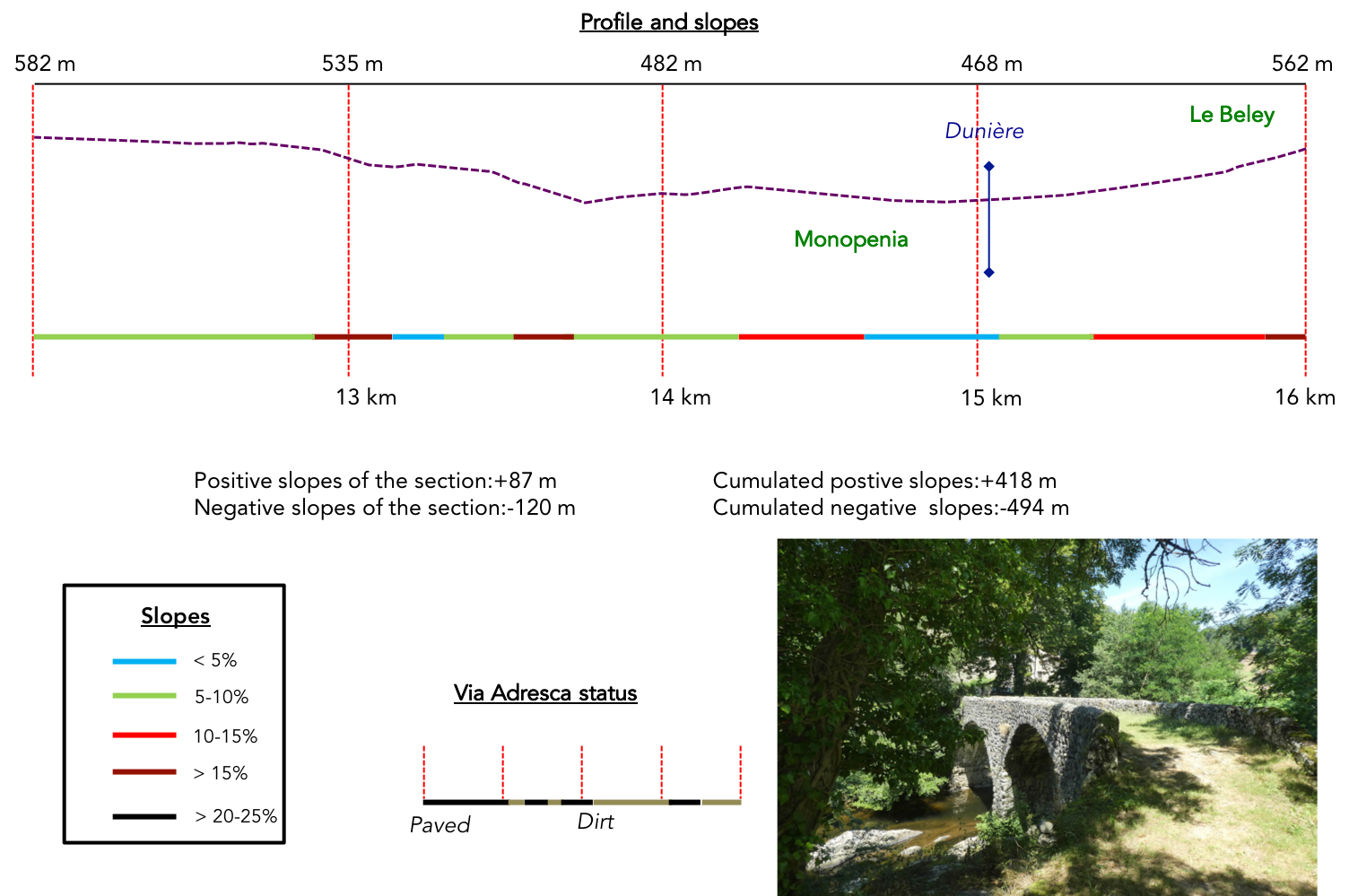
Section 4: In the coolness of the Dunière River

Overview of the route’s challenges: a rather demanding route, though without major difficulties.
| No sooner has the town been left behind than the Via Adresca diverges from the main arteries, venturing onto a humbler road. In the outskirts, it crosses the hamlet of La Bâtisse, a peaceful place where the houses seem like silent observers of life passing by. |
 |
 |
| The road now continues effortlessly, tracing its way through tranquil meadows. It skirts a cemetery, where gray stones rise like witnesses of time, offering a striking contrast to the vibrant green grass surrounding them. |
 |
 |
| But soon, the landscape shifts in mood. The slope becomes pronounced, and the paved road yields to a small, steep trail, almost timid, clinging to the earth like a secret staircase leading downward. . |
 |
 |
| This steep passage is brief, just long enough to feel underfoot the raw texture of the trail before joining a more even departmental road, a ribbon of asphalt running below. |
 |
 |
| The Via Adresca aligns with it briefly, following its course for a few hundred meters, like an indecisive wanderer. |
 |
 |
| Then, in a burst of boldness, it veers off again, plunging into a small dale where the Dunière River winds its way. This generously flowing waterway breathes unexpected life into the descent, where the road once more gives way to a winding path strewn with stones and ancient stories. |
 |
 |
| Beneath the shade of graceful chestnut trees and imposing oaks, the trail is fleeting, as if reluctant to linger. Soon, the asphalt reclaims its place. Yet this dale was once a site of toil: water mills dotted the landscape, harnessing the streams’ power. Not far away, the Moulin du Ranc, now absent from the route, still whispers echoes of an industrious past to the curious. |
 |
 |
| At the locality known as of Liberté, the Via Adresca takes a moment of serenity. It follows a small shaded road, passing near the houses of Reviscole, which seem lost in the benevolent embrace of the forest. Here, nature expresses itself in a gentle symphony of greens, between the slender ashes and leaves dancing in the wind. |
 |
 |
| Yet the road cannot resist the stream’s call, eventually descending again to explore its banks. Throughout this stage, the red-and-white markings of the GR420 intersect with the shells of the Camino de Santiago, embedding this place in a centuries-old network of pilgrimages and inner quests. |
 |
 |
| A wide dirt path then descends to the grand Moulin de Monopenia, a relic of a time when water was humanity’s ally. Here, the rivers powered mechanisms that spun silk threads, a delicate industry that ceased definitively in 1970. Since then, craftsmanship has deserted these places, leaving the walls silent yet proud, recounting their past glory. |
 |
 |

| The path moves gracefully through an enchanting domain, where a delicate stone bridge spans the Dunière River in a simple yet striking leap. The spot breathes tranquility, a haven where coolness and charm seem suspended in the air. Yet the curious mind wonders: how did such a modest stream, barely a whisper of water, once power the great wheels of the mill? Perhaps its course was diverted, for further upstream, the Dunière reveals a more generous flow, almost unrecognizable. |
 |
 |
| A trail, however, bypasses the splendid bridge, refusing to embrace its elegant arch. It remains faithful to the stream’s edge, climbing gently through soft grass kissed by sunlight. The calm here is absolute, and the air carries the coolness of shaded places, amplified by the presence of a tranquil pond, a discreet mirror of the sky. |
 |
 |
| Higher up, the stream asserts its presence: the trail leaps across it, then climbs through a dense forest where tall pines and majestic oaks vie for the canopy. The sturdy trunks watch over this place, a protective cradle for the natural treasures it holds. |
 |
 |
| Soon, the stream bursts into a magical spectacle. It carves its way energetically between massive rocks, forming cascades where water shatters into countless shards of light. These imposing stones, left there by nature’s whimsical elegance, seem arranged with the precision of a jeweler. Who could ever tire of contemplating such a scene? These lively, joyful waterfalls evoke an eternal dance that delights the eye and soothes the soul. |
 |
 |
| The narrow but steadfast trail continues to rise, staying close to the cascades’ melody. It’s as if it refuses to lose touch with this natural symphony, each step a quiet homage to the untamed power and beauty of the water. |
 |
 |
The trail gently slops up until it faces a stone bridge. But “beautiful” is such an inadequate word, isn’t it? This bridge seems to have crossed the ages, born of another time, perhaps the Middle Ages, with its elegant curve and a surface weathered by the passage of years.

| Crossing it only deepens the enchantment. The trail continues its ascent, wrapped in a mineral world where the river crafts a visual melody, playing with the hues of moss-covered rocks. Here, every detail seems preserved in its authenticity. There’s no concrete to mar the scene: the rough-hewn stone blocks, in their rustic simplicity, offer a harmonious continuity to the setting. |
 |
 |
| The houses gradually coming into view, clad in the same ochre stone blocks, seem to belong to the earth as much as they inhabit it. A wider path climbs higher still, until it reaches the grand bridge spanning the Dunière River at the locality of Le Beley. Here, the departmental road D2 imposes itself, but without overwhelming the peaceful atmosphere of the place. |
 |
 |
| The Via Adresca, however, does not linger. It quickly abandons the paved road to plunge into the forest. |
 |
 |
| This forest trail is a haven of gentleness. It meanders softly, barely sloping, among cushions of lush moss and a mix of trees with distinct personalities: tall, resinous pines; venerable chestnuts; and leafy trees whose branches weave a natural vault. |
 |
 |
| Then, the great grafted chestnut trees appear, imposing and majestic, silent witnesses to an ancestral agricultural labor. When the trail finally opens onto a clearing, an overwhelming emotion arises. Everything here radiates splendor. It feels like a moment suspended, where the gaze wanders and the soul finds peace, touched by the grand yet simple beauty of nature. |
 |
 |
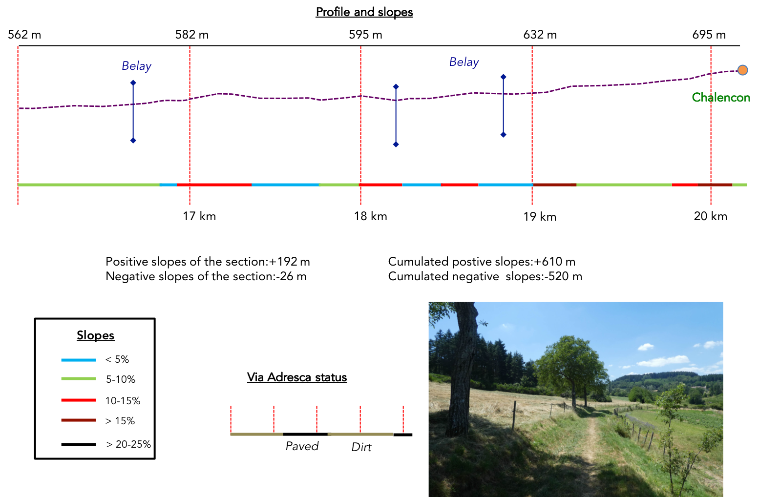
Section 5: Over hill and dale towards Chalencon

Overview of the route’s challenges: gentle climbs, not too demanding, with rare exceptions.
| A wide path stretches then peacefully through the meadows, tracing a winding route between small cultivated plots scattered in the greenery, and fruit trees that seem to offer their harvest with joyful simplicity. The countryside, soft and welcoming, unfolds beneath the vast forests dominating the surrounding hills, woven with silence and light. A tranquility floats in the air, like a whisper disrupted only by the pilgrims’ footsteps. |
 |
 |
| Further ahead, the path delves into the deciduous undergrowth, slightly westward, towards the Florensole area, where tree shadows lengthen, and the ground grows damp. The silence of this forest feels heavy with mystery, broken only by the rustling of leaves under the travelers’ feet. |
 |
 |
| Cows, peacefully grazing beneath the oaks and chestnut trees, watch the pilgrims pass with calm curiosity. Their serene presence, in the heart of nature, forms a still tableau, like a painting from times past. Surely, they’re unaccustomed to seeing these travelers file through their domain like fleeting ghosts. The path, with a gentle slope, slopes up through tall grass, climbing slowly toward the hill, where horizons expand and reinvent themselves with every step. |
 |
 |
| Behind moss-covered walls, vestiges that emerge like relics of time, hides a farm, almost like a small castle, nestled in the valley. Its stones, weathered by centuries, blend seamlessly into the environment, bearing testimony to the resilience of time. On the other side of the hill, however, a modern housing development arises, a strange juxtaposition of old and contemporary styles, a patchwork of contrasts that, despite their divergence, somehow integrates into the landscape. After all, there’s something for everyone. . |
 |
 |
| A final stretch under chestnut trees leads to an imposing farm resembling a flourishing estate. This place, where wood is also harvested, exudes a gentle bliss, as though nature and humans have found a perfect harmony in their coexistence. Again, the forest borders the scene, offering a soothing contrast to human activity while preserving its silent refuge. |
 |
 |
| A little further on, the path reaches the hamlet of Vaugeron, three kilometers from Chalencon or one kilometer from Silhac, where a lodging awaits. The spot seems suspended in time, an ideal stop to catch one’s breath before resuming the route. |
 |
 |
| From here, a modest paved road takes shape, winding between fields and undergrowth, a quiet invitation to further exploration. |
 |
 |
At this moment, a chestnut tree stands before you, a majestic and extraordinary specimen. Could we measure the number of years it has seen? Perhaps a few hundred, undoubtedly. For these ancient giants of the woods can reach incredible ages, sometimes a thousand years. Their grandeur lies not only in their size but in the indelible mark they leave on the memory of the landscape.

| A little further, the paved road runs by the Belay barn, a collection of stone houses dating back to the 16th century. These solidly grounded structures seem to breathe serenity. They reflect a bygone era, still present in their timeworn stones and rooftops. Around them, a few fruit trees are scattered in the meadows, while the omnipresent chestnut trees watch over the scenery like silent sentinels, witnesses to the passing seasons. |
 |
 |
| The paved road then climbs more steeply, traversing a forest where majestic oaks and often frail, withered chestnut trees dominate the landscape. The dense vegetation feels almost oppressive, as though the trees’ shadows encircle the space, stifling the light. The towering silhouettes of oaks seem to guard the pilgrims’ steps, while the thinner, gnarled chestnuts lend a sense of vulnerability to the scene. In places, pines disrupt the dominance of the ashes, as though asserting their stature. Tree canopies sway with the wind, their needles humming a timid, almost mocking melody, disturbing the thick forest silence. |
 |
 |

| A bit higher, the Via Adresca leaves the paved road for a more intimate path plunging into the forest. The path crosses the Belay brook, discreet and almost secret, meandering through the trees. It murmurs softly, like a veiled whisper barely audible under the canopy. |
 |
 |
| The Via Adresca continues to climb, weaving through the deciduous undergrowth. The slope remains gentle, but the terrain becomes more rugged as the path grows rockier. Yet these are not the rounded, polished pebbles of Isère, shaped by centuries and weather, but the sharp-edged stones of Ardèche. Each step echoes against these ancient rocks, witnesses to countless travelers’ wanderings. |
 |
 |
| Chestnut trees reappear here and there, their thick, gnarled trunks standing as guardians of the path. Gradually, the beaten earth gives way to asphalt, a stark contrast signaling the approach to the village of Chalencon, perched above on the hillside. |
 |
 |
A small pond, with brackish, stagnant water, lies lazily among mosses and reeds. The water’s surface is almost swallowed by vegetation, making it hard to discern. This seemingly forgotten spot seems to guard the village entrance, like a secret gateway to another world.

| Such is the way of the Camino de Santiago. The destination feels close, yet a final effort is needed, a last push before reaching it. The slope grows steeper, as if preparing travelers for the beauty ahead. Here at Chalencon, the climb is demanding, but the village at the summit is worth it. |
 |
 |
| The village, with its simple and authentic beauty, finally reveals itself. Perched on its hill, it seems untouched by the world’s turmoil, preserved from the tourist crowds that flock elsewhere. It is one of the hidden gems of the region, one of the most beautiful villages in the country, where every stone seems to tell an ancient story, and every alleyway holds a well-kept secret. The Via Adresca enters the lower part of the village, where the few but welcoming shops offer a much-needed break for weary pilgrims. The village of Chalencon, home to 300 inhabitants, exudes tranquility, authenticity, and a certain gentleness of spirit, far from the crowds and noise. |
 |
 |
 |
 |
| Chalencon, once a Gallic oppidum, still retains traces of its distant past high above the village. These remnants, etched into the rock and soil, testify to an era long gone but still palpable to those who take the time to look. The site later became a Roman garrison, then a barony during the Middle Ages, a time when Chalencon became a strategic crossroads for travelers between the Rhône Valley and Haute-Loire. An imposing fortress was built here, with a castle, keeps, chapels, and ramparts, much of which remains visible in the picturesque streets of the medieval village. As is often the case, these monuments have endured through the ages by adapting to societal changes, yet always respecting the heritage. Even more recent constructions seem harmoniously integrated into this legacy, creating a village where one can get lost, wander, and soak in the history emanating from every stone.
The Porte de Besse, the old city gate, separates the lower town from the upper, holding within it the memory of events that have marked these places. Later renamed the Porte des Autrichiens, it recalls the passage of Austrian troops in 1815, after the defeat at Waterloo. While this gate has undergone numerous modifications over the centuries, it remains a classified monument, a symbol of the village’s history. Today, it has been transformed into a remarkable guesthouse, where travelers can lay down their bags and be enchanted by the magic of the place. |
 |
 |
| The St Pierre Church, founded in the 12th century, has also withstood the passage of time. Modified several times until the 19th century, it retains a bell tower with three bells of varying sizes, echoing the prayers and rites of generations past. |
 |
 |
| The religious history of Ardèche, and more specifically Vivarais, has been deeply marked by divisions since the Wars of Religion. At that time, a significant portion of the population embraced Calvinist teachings from Geneva, leading to severe tensions. Protestants were forced to hide, practicing their faith in secrecy and at great risk. Only in the 1820s did the situation calm, allowing the Protestant community to emerge from the shadows and resume public worship. The first Protestant temple was built here in the 16th century but was destroyed. The current temple, built in 1822, stands at the village’s summit, on the very site of the original one. |
 |
 |
| In the 15th century, Diane de Poitiers, the famous favorite of King Henri II, owned a castle in Chalencon. She was instrumental in fostering the village’s commercial growth by establishing a market and fairs, likely on the grand Valla square near the Porte de Besse. While the castle no longer exists, traces of her influence remain visible here and there, in both the architecture and the spirit of the village. |
 |
 |
The square tower, also called the gallows tower, was later raised to be transformed into a dovecote. Despite this transformation, it remains a striking feature of the village’s medieval architecture. Its imposing silhouette, perched over the landscape, recalls a time of defense and authority when every stone carried profound meaning.

| You could spend hours wandering through the alleys of Chalencon, admiring the beautiful rubble stone houses with mullioned windows, echoes of another era. Or you might sit down at one of the village restaurants to enjoy the local cuisine, basking in the undeniable charm of this timeless place. It’s remarkable that this part of Ardèche, so tranquil, remains relatively deserted, while the southern regions of the country seem overrun by tourism. Ah, the paradoxes of tourism… A true mystery, between those who flee the crowds and those who seek them. |
 |
 |
Official accommodations on the Via Adresca
- Les Blaches, Vernoux-en-Vivarais; 04 75 61 72 13/06 11 95 35 76; Guestroom, dinner, breakfast
- Les Blés d’or, Chalencon; 06 42 83 26 85/04 75 58 15 18; Gîte, dinner, breakfast
- Porte de Besse, Chalencon; 04 75 58 15 18; Guestroom, dinner, breakfast
Pilgrim hospitality/Accueils jacquaires (see introduction)
- Croix Saint André (1)
- Vernoux-en-Vivarais (3)
- Chalencon (1)
Along the Via Adresca, accommodation options are almost always limited. You’re not walking through the touristy South of Ardèche. Lodging is scarce, even on Airbnb, where listings are often unavailable. This list only includes accommodations located directly on the route or within 1 km of the route. The guide published by the Friends of Compostela, however, lists all available lodging addresses, as well as bars, restaurants, and bakeries along the route, even several kilometers off the route. For meals, it’s possible to take a break in Vernoux, which offers all basic services. In Chalencon, which also has shops, lodging is again limited. Make sure to book well in advance.
Feel free to add comments. This is often how you move up the Google hierarchy, and how more pilgrims will have access to the site.
|
 |
Next stage : Stage 14: From Chalencon to Les Nonières |
|
 |
Back to menu |


