In “Ardèche Plein Cœur”
DIDIER HEUMANN, ANDREAS PAPASAVVAS

We divided the course into several sections to make it easier to see. For each section, the maps show the course, the slopes found on the course, and the state of the roads. The courses were drawn on the “Wikilocs” platform. Today, it is no longer necessary to walk around with detailed maps in your pocket or bag. If you have a mobile phone or tablet, you can easily follow routes live.
For this stage, here is the link:
https://fr.wikiloc.com/itineraires-randonnee/foriel-auvergne-rhone-alpes-france-32920711
It is obviously not the case for all pilgrims to be comfortable with reading GPS and routes on a laptop, and there are still many places in France without an Internet connection. Therefore, you’ll find soon a book on Amazon that deals with this course.
If you only want to consult lodging of the stage, go directly to the bottom of the page.
| The Haut Vivarais, on the edge of the Massif Central, is a juxtaposition of small plateaus of medium altitude and hills which can rise up to almost 800 meters above the sea. As the basic structure of the Massif Central is the granite, with flows of volcanic basalts, you find here mainly granites, but also gneiss, transition products of granite. In the coming days, you will only see the volcanoes of Ardèche appear on the horizon, which are emerging on the horizon line that goes towards the Haute-Loire. You walk these days in the large part of the Via Adresca in “Ardèche Plein Cœur” (full heart), which designates the middle part of the department, which is neither to the north nor to the south. You crossed part of it yesterday, because this region extends from the Rhône Valley, at St Péray, to Mont Mézenc, at the limit of the Haute Loire, at the other end. It is in fact a kind of high plateau, cut by deep rivers, in the north as in the south, but also often from one plateau to another.
Here, the meadows, rarely the orchards, rub shoulders with the pines, the beeches, the oaks, and especially the chestnut trees, often passing from the softest reliefs to very steep slopes. You will come across thousands of chestnut trees, some several hundred years old, each more majestic than the next. And to think that this wonder has gone into decline. Today, it is claimed that the country is back to the good old days when the tree covered the whole country. At least, the chestnut of Ardèche has now become an AOC. Long life to chestnut growers!
Today, Via Adresca, the road to Compostela, merges with the GR42/420 track. Therefore, you can now easily trust the red and white marks of the GR or the shell of Compostela. But just a word of advice: always follow the shells because from day to day, the tracks here often diverge. You will end the day in a haven of happiness, the village of Chalencon, perched on the hill, where peace reigns, where it is good to breathe the old stones in the shade of the winding alleys.
Difficulty of the course: Slope variations (+610 meters/-530 meters) are quite substantial for a 20-kilometer stage. It’s still a leg-breaking stage, as generally in the Vivarais, but it’s part of the pleasures of walking in these regions. First there is a continuous climb to Herbasse, then a long descent into the forest towards Savinas. From there, you have to slope down to the bottom of the dale to climb up to Vernoux-en-Vivarais, the large borough of the region located on a plateau. Then, it’s constant ups and downs to reach Chalencon, perched on the hill.

|
Today the advantage is in the pathways over the roads:
- Paved roads: 7.3 km
- Dirt roads: 12.9 km
Sometimes, for reasons of logistics or housing possibilities, these stages mix routes operated on different days, having passed several times on Via Podiensis. From then on, the skies, the rain, or the seasons can vary. But, generally this is not the case, and in fact this does not change the description of the course.
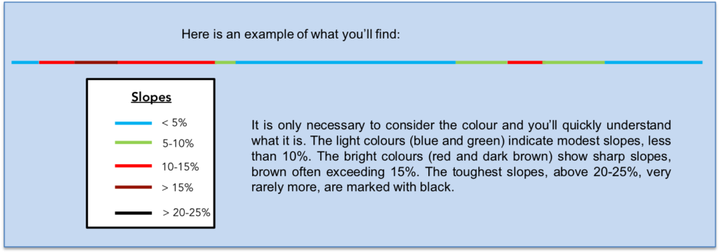
It is very difficult to specify with certainty the incline of the slopes, whatever the system you use.
For “real slopes”, reread the mileage manual on the home page.
Section 1: Ups and downs in forests and glades.

General overview of the difficulties of the route : course which is not easy, with sometimes marked slopes, close to or more than 15%.

| If you have spent the night in one of the two accommodations present in Cerisier, you must return by road to Ponsoye Pass and follow the dirt road which climbs up the hill. |
 |
 |
| The pathway, moderately stony, quickly reaches a fairly dense forest where small chestnut trees clearly dominate. Here, the slope is quite pronounced. |
 |
 |
| Further up, the pathway reaches a clearing and gets to the place called Le Cerisier. |
 |
 |
| Here, you have in front of you the village of Boffres and the road that leads to it from Ponsoye Pass. You are just above the two guest rooms of Cerisier, where you may have spent the night, above the village of Alboussière, in the background. |
 |
 |
| Here, the direction is L’Herbasse, 3 kilometers away. A narrow pathway slopes up in a magnificent moor, in the middle of broom, juniper and wild grass. Here, the dirt is ocher, silty, almost sand. |
 |
 |
| Then, the pathway leaves the wild moor to enter the forest. |
 |
 |
| In the forest, the chestnut trees rule the roost and leave little room for other species. The chestnut is still the king tree of this part of the Ardèche. |
 |
 |
| Then, the pathway comes out of the forest and slopes down on the other side of the hill, with sometimes large stones on the way. The landscape is as bucolic as one could wish, and the small hills of the Ardèche stand out, one behind the other, on the horizon, magnificent, wooded and seemingly almost solitary. |
 |
 |
| Further down, the pathway crosses a small road, oscillates, even slopes up a little. |
 |
 |
From here, there is still a remarkable view of the village of Boffres, its church and its tower.

| The pathway then descends into the brushwood towards the Croix St André, where there is a gîte at the edge of the road. Open or closed? Always call ahead to book on Via Adresca, to avoid surprises. |
 |
 |
| Further afield, Via Adresca descends on a small secondary road. But here you will never be bothered by vehicles. Few people live in these remote areas. |
 |
 |
When you glance at the horizon, you only see forests climbing up the hills, up there near the wind turbines, which are very present on the high hills. There are still so many empty spaces of people in the country.

| The road descends until you find a beautiful house made of rubble and its fountain. It is in these blessed places, rare on the tracks, that you can empty your bottle of warm water and refill it with fresh water, a source of life. |
 |
 |
| And water, you will probably need a little here, because a pathway climbs up the hill in the greenhouse of Muans, in the stones and the chestnut trees. |
 |
 |
Section 2: In the deep forest.

General overview of the difficulties of the route : ups and downs, sometimes demanding in the woods

Sloping up the Herbasse, the slope is quite steep, almost 15%, on ravine ground, in chestnut trees and leafy trees. And stones, there are also in Ardèche.

| At the top of the climb, the slope softens in a magical landscape of moor, brush, broom where the spruces point their noses. Here, you are at a place called l’Herbasse, 8.5 kilometers to Vernoux. |
 |
 |
| The pathway joins a small dirt road which leads to a hamlet. But who would have the audacity to speed up here, far from the world? |
 |
 |
Because, people live here, far from everything, at nearly 800 meters above sea level, arriving by a bush road that is difficult to access, in a cul-de-sac, in a magnificent hamlet of stone houses on a small plateau.

| The pathway climbs further to reach the Serre de Muans forest, where the light does not penetrate, giving an almost apocalyptic landscape. It’s a forest of Douglas firs, gigantic shafts touching the sky, with just a little tuft of greenery at the top. It’s been said many times through the stages that these Oregon fir trees are actually pines, reaching almost 100 meters in height and living up to 500 years. They were imported to Europe in the XIXth century by the English David Douglas. Here, they are young trees, having been planted in the middle of the last century, as explained to us by a friendly inhabitant of the region, a little further down. |
 |
 |
| Further ahead, the forest thins out little by little. The pathway still climbs at a reasonable slope between the bushes which momentarily take over the almost clay soil. |
 |
 |
| Further up, the traditional forest, in which spruces and hardwoods coexist, reasserts itself and the climb is almost complete at a place called Parpaillon. |
 |
 |
| The pathway then wanders a little in the Serre (Forest) de Parpaillon, on the top of the hill between undergrowth of chestnut trees and clearings where even a little wheat grows. |
 |
 |
| Further on, the pathway descends between undergrowth and wheat to pass at a place called Le Gratol. Behind the wheat, the gentle hills of the Vivarais flee towards the horizon. |
 |
 |

| Here, you have to be very careful, do not follow the track along the hedge, but go behind the wheat towards the thickets. Here, the slope is severe, more than 15%. There are even granitic rocks that outcrop. |
 |
 |
| A little further down, the pathway arrives near an isolated stone house, nestled in the hollow of a dale. The shell of Compostela points towards the entrance of the house. You say to yourself that the track should not pass through there. |
 |
 |
And yet, yes, because fortunately the owner was present. He then gave us the history of the region, telling us that all the surrounding forests did not exist around the middle of the last century. Here, there were only big, chubby, grafted chestnut trees, isolated up to the top of the hills. Then came the idea that chestnut husk was good for tanning skins. So, people cut the trees, one after the other, without a second thought. And the tress have never been replanted. From then on, one can still find in the forest trees grafted in the middle of the wild offshoots which have clearly taken over. These forests are in fact armies of wild offspring. It was also during this period that Douglas firs were planted. Then, the wild vegetation took everything away, and the spruces, oaks and beeches arrived, so that one has the illusion, when one walks here, of passing through thousand-year-old forests. It’s amazing the force of nature, isn’t it?
But since then, outside the forests, people have now started replanting real chestnut trees. But, it will take time before they become multi-centenarians like their ancestors.

| Further down, the pathway descends further, through pines and chestnut trees, sometimes through grass, until it reaches a small dirt road. |
 |
 |
| The pathway then arrives on the tarmac at a place called Adreyt de Savinas. Is it a peculiarity of the Ardèche to write adreyt which is in fact an adret, in other words the slope of the valley exposed to the sun as opposed to the shade, which is in the shade? Here, you still have to walk more than 5 kilometers to reach Vernoux-en-Vivarais. |
 |
 |
| Shortly after, the road then crosses the extended hamlet of Savinas. |
 |
 |
| The road comes out of the hamlet and at the end of the plateau, suddenly, you have Vernoux in front of you, a stone’s throw away, the village that the signs have been announcing for miles. But you can guess that there is a dale between the two. It is almost always like this on the Chemin de Compostelle, you will have to go down to the bottom of the valley and slope up the other side, of course, because the “Ardèche Plein Cœur” is made up of a succession of small plateaus interspersed with deep rivers. |
 |
 |
| Via Adresca soon leaves the road and runs between wheat and meadows on a pathway that flattens to the end of the plateau. There, the pathway begins the descent into the dale. |
|
 |
Further, Vernoux-en-Vivarais does not seem to have come closer, really.

| Quickly, the pathway becomes stony and reaches the undergrowth of chestnut trees. The slope varies here between 10% and more than 15%, but overall it is very bearable. |
 |
 |
Section 3: Over hill and dale towards Vivaroux-en-Vivarais.

General overview of the difficulties of the route : demanding ups and downs.

| During the descent to the bottom of the dale, the pathway runs through undergrowth, sometimes along clearings. |
 |
 |
| A little further down, it passes at Mont Flos in front of a magnificent farm and crosses the few beautiful rubble stone houses of the hamlet. |
 |
 |
| From here, it is the paved road. At this point in history, you are lower than Vernoux, but you are not yet at the bottom of the dale. |
 |
 |
| Another moment of respite, and then begins the steepest descent, at more than 15% decline. |
 |
 |
| At the bottom of the dale, at a place called Les Petits Ponts, the Médrand stream flows peacefully. You still took almost 200 meters of negative sloping, which you will have to redo, in positive sloping, at least in large part, over the 2 kilometers of climb to Vernoux. |
 |
 |
| Then, a wide dirt road slopes up on the other side of the dale. Here, the slope is very bearable and the road follows a tributary of the Médrand brook. |
 |
 |
| Further up, the pathway heads to the wastewater treatment plant. To see the size of the work, you presuppose that the village must be quite substantial. |
 |
 |
| And the road always climbs, often straight. You’ll soon see the first houses, well above. |
 |
 |
| The tall oaks and the frail ash trees, perhaps the most elegant of the trees, act as guards of honor. |
 |
 |
| Then, as you approach the borough, tar replaces dirt. |
 |
 |
| The first houses appear, and you guess a stretch of water on a small plateau. |
 |
 |
| Further up, the road arrives below the village near a park. |
 |
 |
Here extends the beautiful Ramiers Lake, where swimming is prohibited, except in summer in the equipped beaches. We are however in summer, and there is nobody at the edge of the lake. All this superb region of Vivarais does not seem to be favored by summer vacationers. Pity!

| The road climbs, passing through the new districts, towards the center of the borough. |
 |
 |
| Vernoux en-Vivarais (2,000 inhabitants) is today a quiet borough, the equal of St Agrève, a little further on the route. In the Middle Ages, it was an important village, a monastery and castles. The ramparts of the village were razed in the middle of the XVIth century, during the Wars of Religion. There remain the remains of the Château de la Tourette, far from here, where the track does not go. The Catholic church, in neo-Gothic style, dates from the XXth century. Its 51-meter bell tower makes this building the tallest in the Ardèche. Here, throughout this region of the Ardèche, the Protestants have not been swept away and there are still significant communities. There is a temple here. |
 |
 |
| You can find all the shops in the main street. |
 |
 |
| Via Adresca leaves the borough following the small departmental road D2, which leads to Silhac and Chalencon. |
 |
 |
Section 4: In the freshness of the Dunière River.

General overview of the difficulties of the route : fairly demanding course, but without major difficulties.

| Quickly, at the exit of the suburbs, Via Adresca forks on a smaller road which heads to the hamlet of La Bâtisse. |
 |
 |
| The road then flattens in the meadows, transits near the cemetery. |
 |
 |
| Further ahead, the road begins to descend and soon a small, very steep pathway takes over. |
 |
 |
| The passage on the pathway is very short. It is only to join the departmental road which runs below. |
 |
 |
| Here, Via Adresca follows the road for a few hundred meters… |
 |
 |
| … which it leaves to descend into a small dale where the large Dunière stream flows. |
 |
 |
| Just below, a tortuous and stony pathway takes over from the road in the undergrowth of chestnut trees, small oaks and hornbeams. But here too the passage on the pathway is short and you’ll quickly find the tar back. In this dale, watermills were used. Near here is the old Ranc mill, where the track does not go. |
 |
 |
| Here you’ll get, under the oaks, at a place called Liberté, and Via Adresca sets off again on a small road, passing near a few houses in Reviscole. |
 |
 |
| Further on, it continues on the road before deciding to go and visit what is happening near the stream. Throughout this stage, the red-white signs of the GR420 coincide with the shells of the Camino de Compostela. |
 |
 |
| A wide dirt road then descends to the large mill of Monopenia. Here, the force of water was used to twist silk threads, an activity that was definitively stopped in 1970. There may not be any more crafts in the country. |
 |
 |

| The pathway crosses the beautiful estate, where a pretty little stone bridge spans the Dunière stream. The site is relaxing, full of freshness and charm. One wonders all the same to understand how such a small trickle of water could turn the wheels of the mill. Or was the water diverted from the stream, because upstream, the Dunière seems more voluminous? |
 |
 |
| The pathway does not take the stone bridge, it stays on the edge of the stream and climbs in the grass passing in front of a body of water. |
 |
 |
| Further up, it crosses the stream and then climbs into the forest where pines and oaks dominate. |
 |
 |
| The pathway follows the very beautiful waterfalls made by the stream in the rocks. Can we not say enough about the pleasure generated by the magic of such sites? |
 |
 |
| Further up, the narrow pathway still climbs along the waterfalls… |
 |
 |
…until you come across a stone bridge. Beautiful, the word is not strong enough, is it?

| The pathway crosses the bridge and continues to climb. The charm still works as much in this mineral world where the water of the river plays with the tones of the rocks. And this all the more so since above, masons did not pour concrete, but kept the stone rubble. |
 |
 |
| The houses are very beautiful here in their ocher stone rubble clothes. The pathway climbs until you find the large bridge over the Dunière River, where the departmental D2 passes, at a place called Le Beley. |
 |
 |
| Via Adresca does not last long on the departmental road, and quickly heads towards the forest. |
 |
 |
| Further on, it is a pleasant forest lane that barely climbs in the mosses, under the pines, chestnut trees and other leafy trees. |
 |
 |
| The large grafted chestnut trees are of a superb majesty, when the pathway comes out into the clearing. |
 |
 |
Section 5: Over hill and dale towards Chalencon.

General overview of the difficulties of the route : climbing not too demanding, with rare exceptions.

| Further afield, the pathway crosses the meadows, with here and there small crops or fruit trees. The countryside is gentle here. |
 |
 |
| A little further on, the pathway returns to the deciduous undergrowth, near Florensole. |
 |
 |
| The cows, at rest under the oaks and chestnut trees, watch the pilgrims pass by. They don’t have to see them every day. The pathway then climbs in the grass, a little more, towards the hill. |
 |
 |
| Behind the moss-covered walls, which are always a great joy to see them on the tracks, nestles in the meadows a farm that looks like a small castle. On the other side, at the top of the hill, a housing estate of recent houses. It takes all tastes. |
 |
 |
| Another small turn under the chestnut trees and the pathway arrives near a large farm which also exploits the wood. There, the pathway returns to the forest. |
 |
 |
| The pathway then gets to a place called Vaugeron, 3 kilometers to Chalencon, or 1 km to Silhac, where there is also a gîte. |
 |
 |
| Shortly after, a road leaves from here between countryside and undergrowth. |
 |
 |
Could we estimate the number of years of life of this extravagant and superb specimen of chestnut? A few hundred years, for sure. Ancestors can live a thousand years.

| The road soon heads to the Belay barn, a complex of beautiful stone houses, dating all the same to the 1XVIth century. Here and there, a few fruit trees in the meadows, and of course many chestnut trees. |
 |
 |
| Further on, the road begins to climb a little stronger, in a forest where oaks predominate. Sometimes the pines make fun of the tall ash trees. |
 |
 |

| A little up, Via Adresca leaves the road for a pathway that slopes uptowards the forest. It crosses the Belay stream which flows discreetly under the beeches. |
 |
 |
| Via Adresca then climbs for quite a long time in the deciduous undergrowth. The slope is quite gentle on a pathway that sometimes becomes a little stonier. But, the pebbles of the Ardèche are not those of the Isère. |
 |
 |
| Still a few chestnut trees to put under the pupil and the road replaces the dirt which arrives under the village of Chalencon. |
 |
 |
A small pond where you can barely make out the water announces the village.

| It is sometimes like this on the Camino de Compostela. You have the goal in front of you and you need a last push. And here it is. The slope is steep to reach the bottom of the village. |
 |
 |
| But, the village deserves it, because it is really a very beautiful village, undoubtedly one of the most beautiful villages in the region, even if the tourists are not in a hurry there. Via Adresca arrives in the lower part of the village (300 inhabitants), where the shops are. |
 |
 |
 |
 |
| Chalencon was first a Gallic oppidum, still very visible above the village. You will get there tomorrow when leaving the village. Then, the place became a Roman garrison and a barony in the Middle Ages. In the Middle Ages, Chalencon was the obligatory place of passage to go from the Rhone Valley to Haute-Loire. A fortress was built here with a castle, dungeons, chapels and ramparts. Much of these vestiges are still very visible in the picturesque streets of the medieval village. As often, transformations have taken place, but they have been made with deep respect for heritage. Even the recent part of the village is in the same spirit. It is really a very beautiful village, where it is good to stroll.
Porte de Besse is the old city gate that marks the limits between the lower and upper village. It was renamed Porte des Austrians, marking the passage of Austrian troops in 1815 after the defeat at Waterloo. It is classified as a historical monument, although it has undergone many modifications. It has now become a remarkable guesthouse. |
 |
 |
| Dating from the XIIth century, the Saint Pierre church underwent modifications until the XIXth century. The bell tower has 3 bells of different sizes. |
 |
 |
| Ardèche and Vivarais in particular have experienced real religious quarrels since the Wars of Religion, when here, a large part of the population rallied to the theses of Calvin, in Geneva. Thereafter the Protestants had to hide, to profess their faith in hiding. It was not until the 1820s that the situation calmed down and that Protestants were able to open the door again. Here, a first temple was built in the XVIth century, then destroyed. The current temple, dates from 1822, built on the site of the first, at the top of the village. |
 |
 |
| Diane de Poitiers owned a castle here in the XVth century, and set up a market and fairs, probably on the large square of Valla, near the Porte de Besse. Traces of her passage remain. |
 |
 |
The square tower, also known as gallows tower, was raised to make a dovecote. It is nonetheless remarkable.

| You could spend long moments here admiring the beautiful rubble stone houses and their mullioned windows, or tasting the undeniable charm of the local restaurants. It’s quite surprising to understand why this part of the Ardèche is deserted, whereas in the south of the country, you sometimes have to jostle to make your way. Ah, the beautiful paradoxes of tourism! |
 |
 |
Lodging


